Siagne
The Siagne is a short river that flows through the Var and Alpes-Maritimes departments, in southeastern France.
| Siagne La Siagne (French) | |
|---|---|
 Gorges of the Siagne | |
  | |
| Location | |
| Country | France |
| Physical characteristics | |
| Source | |
| - location | near Escragnolles |
| - elevation | 640 m (2,100 ft) |
| Mouth | |
| - location | Mediterranean Sea |
| - coordinates | 43°31′52″N 6°56′54″E / 43.531°N 6.9482°E |
| Length | 44 km (27 mi) |
| Basin size | 512 km2 (198 sq mi) |
| Discharge | |
| - average | Mediterranean Sea |
Geography change
The Siagne river has a length of 44.3 km (28 mi) and a drainage basin with an area of approximately 556 km2 (215 sq mi).[1]
Its average yearly discharge (volume of water which passes through a section of the river per unit of time) is 8.75 cubic metres per second at Pégomas, near Cannes.
Course change
The Siagne starts on the south side of the Audibergue mountain, in the commune of Escragnolles, Alpes-Maritimes department, at an elevation of about 1,367 m (4,485 ft).[2] It then flows to the southwest through the departments of Alpes-Maritimes and Var. For much of its length, it forms the border between the two departments.
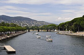
Finally, the river flows into the Mediterranean Sea at the city of Mandelieu-la-Napoule.[3]
The Siagne flows through 2 departments and 13 communes, in one region:[1]
Main tributaries change
The main tributaries of the Siagne river are:[1]
|
Left tributaries:
|
|
Right tributaries:
|
Gallery change
-
 Gorges of the Siagne
 -
 Mouth of the Siagne in Mandelieu-la-Napoule
 -
 Mouth of the Siagne in Mandelieu-la-Napoule


Related pages change
References change
- ↑ 1.0 1.1 1.2 "La Siagne (Y55-0400)" (in French). SANDRE - Portail national d'accès aux référentiels sur l'eau. Archived from the original on 3 March 2016. Retrieved 6 October 2016.
- ↑ "Source du Siagne" (in French). Géoportail. Retrieved 6 October 2016.
- ↑ "Embouchure du Siagne" (in French). Géoportail. Retrieved 6 October 2016.