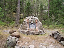
Struve Geodetic Arc
The Struve Geodetic Arc is a chain of survey triangulations that go from Hammerfest in Norway to the Black Sea. They go through ten countries and over 2,820 kilometres (1,750 miles). It made the first accurate measurement of a meridian arc.
| Struve Geodetic Arc | |
|---|---|
 The northernmost station of the Struve Geodetic Arc is located in Fuglenes, Norway. | |
 Map of the Struve Geodetic Arc where red points identify the World Heritage Sites. | |
| General information | |
| Type | Ensemble of memorable sites |
| Location | Estonia, Belarus, Finland, Latvia, Lithuania, Norway, Moldova, Russia, Sweden, and Ukraine |
| Coordinates | 59°3′28″N 26°20′16″E / 59.05778°N 26.33778°E |
| Opened | Geodetic Arc |
| Design and construction | |
| Architect | Friedrich Georg Wilhelm von Struve |
| Official name | Struve Geodetic Arc |
| Criteria | ii, iii, vi |
| Reference | 1187 |
| Inscription | 2005 (29th Session) |


The chain was made and used by the German-born Russian scientist Friedrich Georg Wilhelm von Struve in the years 1816 to 1855. He did this to find the exact size and shape of the earth. At that time, the chain passed through two countries: Union of Sweden-Norway and the Russian Empire. The Arc's first point is in Tartu Observatory. This is where Struve did much of his research.
In 2005, the chain was added on the World Heritage List. There are 34 plaques or obelisks out of the original 265.
Chain change
Norway change
- Fuglenes in Hammerfest
- Raipas in Alta
- Luvdiidcohkka in Kautokeino
- Baelljasvarri in Kautokeino
Sweden change
- "Pajtas-vaara" (Tynnyrilaki) in Kiruna
- "Kerrojupukka" (Jupukka) in Pajala
- Pullinki in Övertorneå
- "Perra-vaara" (Perävaara) in Haparanda
Finland change
- Stuor-Oivi (currently Stuorrahanoaivi) in Enontekiö (68°40′57″N 22°44′45″E / 68.68250°N 22.74583°E)
- Avasaksa (currently Aavasaksa) in Ylitornio (66°23′52″N 23°43′31″E / 66.39778°N 23.72528°E)
- Torneå (currently Alatornion kirkko) in Tornio (65°49′48″N 24°09′26″E / 65.83000°N 24.15722°E)
- Puolakka (currently Oravivuori) in Korpilahti (61°55′36″N 25°32′01″E / 61.92667°N 25.53361°E)
- Porlom II (currently Tornikallio) in Lapinjärvi (60°42′17″N 26°00′12″E / 60.70472°N 26.00333°E)
- Svartvira (currently Mustaviiri) in Pyhtää (60°16′35″N 26°36′12″E / 60.27639°N 26.60333°E)
Russia change
- "Mäki-päälys" (Mäkipäällys (Finland 1917/1920-1940) in Hogland (Suursaari)
- "Hogland, Z" (Gogland, Tochka Z) in Hogland (60°5′9.8″N 26°57′37.5″E / 60.086056°N 26.960417°E)
Estonia change
- "Woibifer" (Võivere) in Väike-Maarja Parish (59°03′28″N 26°20′16″E / 59.05778°N 26.33778°E)
- "Katko" (Simuna) in Väike-Maarja Parish (59°02′54″N 26°24′51″E / 59.04833°N 26.41417°E)
- "Dorpat" (Tartu Observatory) in Tartu. (58°22′43.64″N 26°43′12.61″E / 58.3787889°N 26.7201694°E)
Latvia change
- "Sestu-Kalns" (Ziestu) in Ērgļu novads (56°50′24″N 25°38′12″E / 56.84000°N 25.63667°E)
- "Jacobstadt" in Jēkabpils (56°30′05″N 25°51′24″E / 56.50139°N 25.85667°E)
Lithuania change
- "Karischki" (Gireišiai) in Panemunėlis (55°54′09″N 25°26′12″E / 55.90250°N 25.43667°E)
- "Meschkanzi" (Meškonys) in Nemenčinė (54°55′51″N 25°19′00″E / 54.93083°N 25.31667°E)
- "Beresnäki" (Paliepiukai) in Nemėžis (54°38′04″N 25°25′45″E / 54.63444°N 25.42917°E)
Belarus change
- "Tupischki" (Tupishki) in Oshmyany district (54°17′30″N 26°2′43″E / 54.29167°N 26.04528°E)
- "Lopati" (Lopaty) in Zelva district (53°33′38″N 24°52′11″E / 53.56056°N 24.86972°E)
- "Ossownitza" (Ossovnitsa) in Ivanovo district (52°17′22″N 25°38′58″E / 52.28944°N 25.64944°E)
- "Tchekutsk" (Chekutsk) in Ivanovo district (52°12′28″N 25°33′23″E / 52.20778°N 25.55639°E)
- "Leskowitschi" (Leskovichi) in Ivanovo district (52°9′39″N 25°34′17″E / 52.16083°N 25.57139°E)
Moldova change
- "Rudi" near Rudi village, Soroca district (48°19′08″N 27°52′36″E / 48.31889°N 27.87667°E)
Ukraine change
- Katerinowka in Antonivka, Khmelnytsky Oblast (49°33′57″N 26°45′22″E / 49.56583°N 26.75611°E )
- Felschtin in Hvardiiske, Khmelnytsky Oblast (49°19′48″N 26°40′55″E / 49.33000°N 26.68194°E )
- Baranowka in Baranivka, Khmelnytsky Oblast (49°08′55″N 26°59′30″E / 49.14861°N 26.99167°E )
- Staro-Nekrassowka (Stara Nekrasivka) in Nekrasivka, Odesa Oblast (45°19′54″N 28°55′41″E / 45.33167°N 28.92806°E )
Other websites change
Media related to Struve Geodetic Arc at Wikimedia Commons