Yonne (river)
The Yonne is a river in the northern half of France. It flows mainly through the western part of the Bourgogne-Franche-Comté region, giving its name to the Yonne department and to several communes. It is the main left tributary of the Seine river.
| Yonne | |
|---|---|
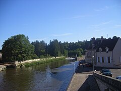
 The Yonne in Auxerre | |
 | |
| Location | |
| Country | France |
| Physical characteristics | |
| Source | |
| - location | Morvan |
| - elevation | 730 m (2,400 ft) |
| Mouth | |
| - location | Seine |
| - coordinates | 48°23′15″N 2°57′30″E / 48.38750°N 2.95833°E |
| Length | 292 km (181 mi) |
| Basin size | 10,887 km2 (4,203 sq mi) |
| Discharge | |
| - average | 95 m3/s (3,400 cu ft/s) |
| Basin features | |
| Progression | Seine→ English Channel |
The river was named during the Roman Empire as Icauna, a Latin word that likely came from the Celtic name for the river.[1]
Geography change
The Yonne river has a length of 292.3 km (181.6 mi) and a drainage basin with an area of 10,836 km2 (4,184 sq mi).[2]
Its average yearly discharge (volume of water which passes through a section of the river per unit of time) is 91.70 cubic metres per second at Courlon-sur-Yonne.[3]
 |
Course change
The source of the Yonne is on the Prénely mountain on the southern end of the Morvan hills in the Glux-en-Glenne commune, Nièvre department, at an altitude of about 738 m (2,421 ft).[4]
.jpg)
The Yonne flows, in general, from the southeast to the northwest and passes through the 115 communes, most of them in the Bourgogne-Franche-Comté region; the main communes are:[2]
- Nièvre (58): Corbigny, Clamecy
- Yonne (89): Auxerre, Joigny, Sens, Pont-sur-Yonne, Villeneuve-sur-Yonne
- Seine-et-Marne (77): Montereau-Fault-Yonne
Finally, it flows, as a left tributary, into the Seine river in the town of Montereau-Fault-Yonne, at 47 m (154 ft) of altitude.[5]
Main tributaries change
The main tributaries of the Yonne are:
Gallery change
-
 View of Auxerre and the Yonne
 -
 Sens on the Yonne river
 -
 Saint-Aubin-sur-Yonne and a bridge on the Yonne river
 -
 Clamecy and the Yonne river
 -
 Confluence at Montereau-Fault-Yonne, the Seine to the left and the Yonne to the right.

.jpg)


Related pages change
References change
- ↑ William Smith (1854). "Icaunas". Dictionary of Greek and Roman Geography. Retrieved 27 November 2014.
- ↑ 2.0 2.1 "L'Yonne (F3--0200)" (in French). SANDRE - Portail national d'accès aux référentiels sur l'eau. Archived from the original on 3 March 2016. Retrieved 27 November 2014.
- ↑ 3.0 3.1 "L'Yonne à Courlon-sur-Yonne (H2721010)" (in French). Banque Hydro. Archived from the original on 7 June 2016. Retrieved 21 June 2017.
- ↑ "Source de l'Yonne" (in French). Géoportail. Retrieved 27 November 2014.
- ↑ "Confluence de l'Yonne" (in French). Géoportail. Retrieved 27 November 2014.
- ↑ "Le Beuvron (F30-0400)" (in French). SANDRE - Portail national d'accès aux référentiels sur l'eau. Archived from the original on 10 June 2015. Retrieved 27 November 2014.
- ↑ "La Cure (F31-0400)" (in French). SANDRE - Portail national d'accès aux référentiels sur l'eau. Archived from the original on 10 July 2015. Retrieved 27 November 2014.
- ↑ "Le Serein (F32-0400)" (in French). SANDRE - Portail national d'accès aux référentiels sur l'eau. Archived from the original on 24 May 2015. Retrieved 27 November 2014.
- ↑ "L'Armancon (F3--0210)" (in French). SANDRE - Portail national d'accès aux référentiels sur l'eau. Archived from the original on 3 March 2016. Retrieved 27 November 2014.
- ↑ "La Vanne (F35-0400)" (in French). SANDRE - Portail national d'accès aux référentiels sur l'eau. Archived from the original on 3 March 2016. Retrieved 27 November 2014.
Other websites change
- Banque Hydro - Station H2721010 - L'Yonne à Courlon-sur-Yonne (Synthèse) Archived 2016-06-07 at the Wayback Machine (in French)