Cher (river)
The Cher is a river in central France. It is a left tributary of the Loire River. It flows through several regions of France.
| Cher Cher (French) | |
|---|---|
 The Cher | |
.png) | |
| Location | |
| Country | France |
| Physical characteristics | |
| Source | |
| - location | Massif Central |
| - elevation | 762 m (2,500 ft) |
| Mouth | |
| - location | Loire |
| - coordinates | 47°20′33″N 0°28′49″E / 47.34250°N 0.48028°E |
| Length | 367.8 km (228.5 mi) |
| Basin size | 13,718 km2 (5,297 sq mi) |
| Discharge | |
| - average | 104 m3/s (3,700 cu ft/s) |
| Basin features | |
| Progression | Loire→ Atlantic Ocean |
The Cher and Loir-et-Cher departments are named after this river.
Geography change
The Cher is 367.8 kilometres (228.5 miles) long. Its drainage basin covers 13,920 square kilometres (5,375 square miles).[1]
Its average yearly discharge (volume of water which passes through a section of the river per unit of time) is 92.60 m3/s (3,270 cu ft/s) at Tours, Indre-et-Loire (1966 - 2017), near its mouth.[2]

Average monthly discharge (m3/s) at Tours
Course change
The Cher starts in the Massif Central, in the Mérinchal municipality, Creuse department, Nouvelle-Aquitaine region. It starts at an altitude of about 715 metres (2,346 feet).[3]
The Cher flows, in general, to the northwest. It goes through the following regions, departments and communes:[1]
- Nouvelle-Aquitaine region
- Auvergne-Rhône-Alpes region
- Centre-Val de Loire region
- Cher: Ainay-le-Vieil, Bouzais, Saint-Amand-Montrond, Châteauneuf-sur-Cher, Colombiers, Corquoy, Crézançay-sur-Cher, Drevant, Épineuil-le-Fleuriel, Farges-Allichamps, Foëcy, La Groutte, Lapan, Lunery, Méry-sur-Cher, Nozières, Orval, La Perche, Quincy, Saint-Florent-sur-Cher, Saint-Caprais, Saint-Georges-de-Poisieux, Saint-Georges-sur-la-Prée, Saint-Loup-des-Chaumes, Thénioux, Vallenay, Venesmes, Vierzon
- Loir-et-Cher : Angé, Bourré, La Chapelle-Montmartin, Châtillon-sur-Cher, Châtres-sur-Cher, Châteauvieux, Couddes, Faverolles-sur-Cher, Gièvres, Mareuil-sur-Cher, Mennetou-sur-Cher, Monthou-sur-Cher, Montrichard, Pouillé,Selles-sur-Cher, Saint-Aignan, Saint-Georges-sur-Cher, Saint-Julien-sur-Cher, Seigy, Thésée, Villefranche-sur-Cher.
- Indre : Chabris
- Indre-et-Loire : Athée-sur-Cher, Azay-sur-Cher, Bléré, Chenonceaux, Chisseaux, Civray-de-Touraine, La Croix-en-Touraine, Dierre, Larçay, La Riche, Saint-Avertin, Saint-Genouph, Savonnières, Tours, Véretz, Villandry.
At its end, the Cher flows into the Loire River at the bec du Cher ("beak of the Cher")[N 1] in the Regional nature park Loire-Anjou-Touraine (Parc naturel régional Loire-Anjou-Touraine) in Villandry. That is about 20 kilometres (12 miles) west of the city of Tours, in the Indre-et-Loire department, at 38 metres (125 feet) of altitude.[4]
Main tributaries change
The main tributaries, with a length greater than 50 km, of the Cher are:
Gallery change
-
 The Cher at Villeneuve-sur-Cher.
 -
 Château de Chenonceau over the Cher river.
 -
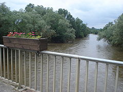
 Bridge over the Cher in Saint-Florent-sur-Cher.
 -
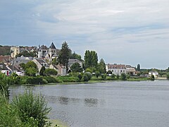 The Cher river at Saint-Aignan.
 -
 The Cher river at Montrichard.
,_le_Cher.JPG)


.jpg)

Related pages change
Notes change
- ↑ The French word bec (beak or bill in English) means, in this and similar cases, the confluence of two rivers.
References change
- ↑ 1.0 1.1 "le Cher (K---0090)" (in French). SANDRE - Portail national d'accès aux référentiels sur l'eau. Archived from the original on 3 March 2016. Retrieved 29 December 2014.
- ↑ "Le Cher à Tours (Pont Saint Sauveur)" (in French). Banque Hydro. Archived from the original on 1 February 2019. Retrieved 5 August 2017.
- ↑ "Source de le Cher" (in French). Géoportail. Retrieved 29 December 2014.
- ↑ "Confluence de le Cher" (in French). Géoportail. Retrieved 29 December 2014.
- ↑ "Fiche cours d'eau: la Tardes (K51-0300)" (in French). SANDRE - Portail national d'accès aux référentiels sur l'eau. Archived from the original on 2 December 2013. Retrieved 29 December 2014.
- ↑ "Fiche cours d'eau: l'Arnon (K6--0240)" (in French). SANDRE - Portail national d'accès aux référentiels sur l'eau. Archived from the original on 26 November 2015. Retrieved 29 December 2014.
- ↑ "Fiche cours d'eau: le Fouzon (K65-0300)" (in French). SANDRE - Portail national d'accès aux référentiels sur l'eau. Archived from the original on 3 March 2016. Retrieved 29 December 2014.
- ↑ "Fiche cours d'eau: l'Aumance (K53-0300)" (in French). SANDRE - Portail national d'accès aux référentiels sur l'eau. Archived from the original on 21 November 2013. Retrieved 29 December 2014.
- ↑ "Fiche cours d'eau: l'Yèvre (K5--0230)" (in French). SANDRE - Portail national d'accès aux référentiels sur l'eau. Archived from the original on 3 March 2016. Retrieved 29 December 2014.
- ↑ "Fiche cours d'eau: la Sauldre (K6--0250)" (in French). SANDRE - Portail national d'accès aux référentiels sur l'eau. Archived from the original on 3 March 2016. Retrieved 29 December 2014.