Ahipara
town in New Zealand
Ahipara is a town in the Far North District, New Zealand. It is located 14 kilometers south west of Kaitaia and Pukepoto is in between these two. It has a primary school in the township and is very popular with surfing. It has suffered from two fires in February 2019 and October 2020.
Ahipara | |
|---|---|
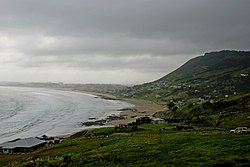
 Ahipara Bay with Whangatauatia Maunga to the right | |
 | |
| Coordinates: 35°10′17″S 173°9′12″E / 35.17139°S 173.15333°E | |
| Country | New Zealand |
| Region | Northland Region |
| District | Far North District |
| Ward | Te Hiku |
| Electorates | |
| Government | |
| • Territorial Authority | Far North District Council |
| • Regional council | Northland Regional Council |
| Area | |
| • Total | 4.53 km2 (1.75 sq mi) |
| Population (June 2022)[2] | |
| • Total | 1,450 |
| • Density | 320/km2 (830/sq mi) |
| Postcode | 0481 |
References
change- ↑ "ArcGIS Web Application". statsnz.maps.arcgis.com. Retrieved 24 March 2022.
- ↑ "Population estimate tables - NZ.Stat". Statistics New Zealand. Retrieved 25 October 2022.