Aksai Chin
Aksai Chin (Urdu: اکسای چن, Chinese: 阿克赛钦, Ākèsàiqīn) is a region of Kashmir . 37,555 km² (16,481 sq mi) which lies at the juncture of China, Pakistan, and India. It consists of about one fifth of Kashmir and one of the driest place and true desert in the world that receive less rain than the Polar desert.
It is ruled by China but claimed by the Republic of India. Aksai Chin is one of the two main border disputes between India and China. The other is the dispute over Arunachal Pradesh. Aksai Chin (the name literally means "Chin's desert of white stones") is a very large high-altitude hot desert of salt with sand dunes and yareta (a type of cushioned plants) that reaches heights up to 4,500 metres. It covers an area of 37,555 km² (16,481 sq mi) of the disputed territory. Geographically part of the Tibetan Plateau, Aksai Chin itself is a plateau and it is often called the "Soda Plain". The region is almost uninhabited, has no permanent settlements, and receives no rain or snow as the Himalayan and other mountains block the rains from the Indian monsoon. Pakistan recognizes it as part of China, however India has objected to this and claims all the territory. In boundary talks in 1960 Chinese officials shown a map drawn by General Staff of the Chinese Army in 1918 shows the territory as part of China. However the map was not published hence its authenticity is doubtful although another document in 1943 created by Bureau of Survey of Chinese Ministry of National Defence shows all of the territory as part of China.
-
 Map showing it as part of China
 -
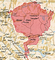 True Map of Aksai Chin as per Indian claim

