Albany, Western Australia
port city in Western Australia, Australia
Albany is a city on the south coast of Western Australia. In 2006, there were 25,196 people living in Albany.[3] The city centre is in between two hills, Mount Melville and Mount Clarence.
| Albany Western Australia | |||||||||
|---|---|---|---|---|---|---|---|---|---|
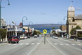
 York Street in Albany | |||||||||
 | |||||||||
| Coordinates | 35°01′22″S 117°52′53″E / 35.02278°S 117.88139°E | ||||||||
| Population | 33,145 (2016 census)[1] (42nd) | ||||||||
| • Density | 111.524/km2 (288.85/sq mi) | ||||||||
| Established | 26 December 1826 | ||||||||
| Postcode(s) | 6330 | ||||||||
| Area | 297.2 km2 (114.7 sq mi)[2] (2011 urban) | ||||||||
| Time zone | AWST (UTC+8) | ||||||||
| Location | |||||||||
| LGA(s) | City of Albany | ||||||||
| State electorate(s) | Albany | ||||||||
| Federal division(s) | O'Connor | ||||||||
| |||||||||
Early history
changeAlbany is built on King George Sound, named by Captain Vancouver in 1791.[4] Major Edmund Lockyer started the first settlement here on 21 January 1827.[4] The Governor of Western Australia, James Stirling, named the city Albany in 1832 after Prince Frederick, Duke of York and Albany, the second son of King George III.[4]
References
change- ↑ Australian Bureau of Statistics (27 June 2017). "Albany (Sighicant Urban Area)". 2016 Census QuickStats. Retrieved 5 January 2018.
- ↑ "2011 Census Community Profiles: Albany". ABS Census. Australian Bureau of Statistics. Archived from the original on 29 January 2018. Retrieved 15 September 2016.
- ↑ Australian Bureau of Statistics (25 October 2007). "Albany (Urban Centre/Locality)". 2006 Census QuickStats. Retrieved 2007-08-25. Consists of Albany SSD (Central) and the State Suburbs of Milpara, Gledhow, McKail, Bayonet Head, Collingwood and Lower King in the 2006 census.
- ↑ 4.0 4.1 4.2 "Landgate > History of country town names". landgate.wa.gov.au. Archived from the original on 19 May 2009. Retrieved 28 March 2010.
Wikimedia Commons has media related to Albany, Western Australia.
