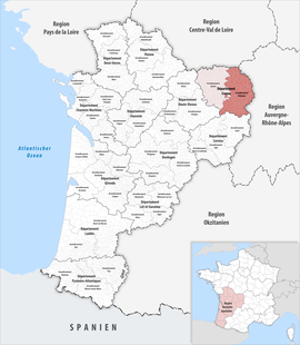
Arrondissement of Aubusson
The arrondissement of Aubusson is an arrondissement of France, in the Creuse department, Nouvelle-Aquitaine region. Its capital is the city of Aubusson.
Aubusson | |
|---|---|
 Location within the region Nouvelle-Aquitaine | |
| Country | France |
| Region | Nouvelle-Aquitaine |
| Department | Creuse |
| No. of communes | 129 |
| Subprefecture | Aubusson |
| Area | 2,828.7 km2 (1,092.2 sq mi) |
| Population (Jan. 2019)[1] | 43,625 |
| INSEE code | 231 |
History
changeWhen the Creuse department was created on 1800, the arrondissement of Aubusson was part of that original department.[2]
Geography
changeThe arrondissement of Aubusson is the smallest arrondissement of the department both in area, 2,538.8 km2 (980.2 sq mi),[3] and population (37,123 inhabitants).[4]
The arrondissement of Aubusson is the most southern arrondissement of the Creuse department. It is bordered to the northeast by the Allier department, to the east by the Puy-de-Dôme department, to the south by the Corrèze department, to the west by the Haute-Vienne department and to the north by the arrondissement of Guéret.
Composition
changeCantons
changeAfter the reorganisation of the cantons in France,[5] cantons are not subdivisions of the arrondissements so they could have communes that belong to different arrondissements.
In the arrondissement of Aubusson, only three cantons do not have all their "communes" in the arrondissement: (Ahun, Bourganeuf, Gouzon). The following table shows the distribution of the "communes" in the cantons and arrondissements:
| INSEE Code |
Canton | Arrondissements | Total | |
|---|---|---|---|---|
| Aubusson | Guéret | |||
| 2301 | Ahun | 10 | 17 | 27 |
| 2302 | Aubusson | 21 | 21 | |
| 2303 | Auzances | 35 | 35 | |
| 2305 | Bourganeuf | 4 | 13 | 17 |
| 2308 | Évaux-les-Bains | 17 | 17 | |
| 2309 | Felletin | 19 | 19 | |
| 2310 | Gouzon | 12 | 13 | 25 |
Communes
changeThe arrondissement of Aubusson has 118 communes; they are (with their INSEE codes):[6]
- Alleyrat (23003)
- Arfeuille-Châtain (23005)
- Ars (23007)
- Aubusson (23008)
- Auge (23009)
- Auzances (23013)
- Banize (23016)
- Basville (23017)
- Beissat (23019)
- Bellegarde-en-Marche (23020)
- Blessac (23024)
- Bosroger (23028)
- Brousse (23034)
- Budelière (23035)
- Bussière-Nouvelle (23037)
- Chamberaud (23043)
- Chambon-sur-Voueize (23045)
- Chambonchard (23046)
- Champagnat (23048)
- Chard (23053)
- Charron (23054)
- Chavanat (23060)
- Châtelard (23055)
- Chénérailles (23061)
- Clairavaux (23063)
- Crocq (23069)
- Croze (23071)
- Dontreix (23073)
- Évaux-les-Bains (23076)
- Faux-la-Montagne (23077)
- Felletin (23079)
- Flayat (23081)
- Fontanières (23083)
- Fransèches (23086)
- Féniers (23080)
- Gentioux-Pigerolles (23090)
- Gioux (23091)
- Issoudun-Létrieix (23097)
- La Chaussade (23059)
- La Courtine (23067)
- La Mazière-aux-Bons-Hommes (23129)
- La Nouaille (23144)
- La Serre-Bussière-Vieille (23172)
- La Villedieu (23264)
- La Villeneuve (23265)
- La Villetelle (23266)
- Lavaveix-les-Mines (23105)
- Le Chauchet (23058)
- Le Compas (23066)
- Le Donzeil (23074)
- Le Mas-d'Artige (23125)
- Le Monteil-au-Vicomte (23134)
- Les Mars (23123)
- Lioux-les-Monges (23110)
- Lupersat (23113)
- Lussat (23114)
- Lépaud (23106)
- Magnat-l'Étrange (23115)
- Mainsat (23116)
- Malleret (23119)
- Mautes (23127)
- Moutier-Rozeille (23140)
- Mérinchal (23131)
- Nouhant (23145)
- Néoux (23142)
- Peyrat-la-Nonière (23151)
- Pontcharraud (23156)
- Poussanges (23158)
- Puy-Malsignat (23159)
- Reterre (23160)
- Rougnat (23164)
- Royère-de-Vassivière (23165)
- Saint-Agnant-près-Crocq (23178)
- Saint-Alpinien (23179)
- Saint-Amand (23180)
- Saint-Avit-de-Tardes (23182)
- Saint-Avit-le-Pauvre (23183)
- Saint-Bard (23184)
- Saint-Chabrais (23185)
- Saint-Dizier-la-Tour (23187)
- Saint-Domet (23190)
- Saint-Frion (23196)
- Saint-Georges-Nigremont (23198)
- Saint-Julien-la-Genête (23203)
- Saint-Julien-le-Châtel (23204)
- Saint-Junien-la-Bregère (23205)
- Saint-Loup (23209)
- Saint-Maixant (23210)
- Saint-Marc-à-Frongier (23211)
- Saint-Marc-à-Loubaud (23212)
- Saint-Martial-le-Mont (23214)
- Saint-Martial-le-Vieux (23215)
- Saint-Martin-Château (23216)
- Saint-Maurice-près-Crocq (23218)
- Saint-Merd-la-Breuille (23221)
- Saint-Michel-de-Veisse (23222)
- Saint-Moreil (23223)
- Saint-Médard-la-Rochette (23220)
- Saint-Oradoux-de-Chirouze (23224)
- Saint-Oradoux-près-Crocq (23225)
- Saint-Pardoux-Morterolles (23227)
- Saint-Pardoux-d'Arnet (23226)
- Saint-Pardoux-le-Neuf (23228)
- Saint-Pardoux-les-Cards (23229)
- Saint-Pierre-Bellevue (23232)
- Saint-Priest (23234)
- Saint-Quentin-la-Chabanne (23238)
- Saint-Silvain-Bellegarde (23241)
- Saint-Sulpice-les-Champs (23246)
- Saint-Yrieix-la-Montagne (23249)
- Sainte-Feyre-la-Montagne (23194)
- Sannat (23167)
- Sermur (23171)
- Sous-Parsat (23175)
- Tardes (23251)
- Vallière (23257)
- Verneiges (23259)
- Viersat (23261)
The communes in the arrondissement with more inhabitants are:
| INSEE code |
Commune | Population[4] (2014) |
Canton | Intercommunality |
|---|---|---|---|---|
| 23008 | Aubusson | 3,591 | Aubusson | Creuse Grand Sud |
| 23079 | Felletin | 1,700 | Felletin | Creuse Grand Sud |
| 23076 | Évaux-les-Bains | 1,393 | Évaux-les-Bains | Pays de Boussac, Carrefour des Quatre Provinces, Evaux-Les-Bains – Chambon-sur-Voueize |
| 23013 | Auzances | 1,288 | Auzances | Chénérailles, Auzances – Bellegarde et Haut Pays Marchois |
| 23045 | Chambon-sur-Voueize | 930 | Évaux-les-Bains | Pays de Boussac, Carrefour des Quatre Provinces, Evaux-Les-Bains – Chambon-sur-Voueize |
Related pages
changeReferences
change- ↑ "Téléchargement du fichier d'ensemble des populations légales en 2019". The National Institute of Statistics and Economic Studies. 28 December 2020.
- ↑ "Historique de la Creuse". Le SPLAF (in French). Retrieved 6 September 2016.
- ↑ "Arrondissement d'Aubusson (231)". Comparateur de territoire (in French). Institut national de la statistique et des études économiques - INSEE. Retrieved 22 May 2017.
- ↑ 4.0 4.1 "Régions, départements, arrondissements, cantons et communes" (PDF). Populations légales 2014 (in French). Institut national de la statistique et des études économiques - INSEE. Retrieved 22 May 2017.
- ↑ "Décret n° 2014-161 du 17 février 2014 portant délimitation des cantons dans le département de la Creuse" (in French). Legifrance.gouv.fr. Retrieved 14 April 2015.
- ↑ "Arrondissement d'Aubusson (231)". Géographie administrative et d'étude (in French). Institut national de la statistique et des études économiques - INSEE. Retrieved 22 May 2017.