Beerangali
union council in Khyber Pakhtunkhwa, Pakistan
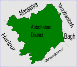
Beeran Gali (also known as 'Berin Gali' or 'Baran Gali') is a Union Council of Abbottabad District, in the Khyber Pakhtunkhwa province of Pakistan.[2]
Beeran Gali | |
|---|---|
 Berin Gali is in Abbottabad district. | |
| Coordinates: 34°11′40″N 73°21′50″E / 34.19444°N 73.36389°E | |
| Country | |
| Province | Khyber Pakhtunkhwa |
| District | Abbottabad |
| Tehsil | Abbottabad |
| Government | |
| • Nazim | Sardar Lal Khan Anwar[1] |
| • Naib Nazim | Sardar Muhammad Iqbal Khan |
| Population | |
| • Total | 12,329 |
History
changeThis area used to be called Baad Burhan and is mentioned by Al Biruni in his famous book Ta'rikh al-Hind, The Chronicles of India, from 1030. Al Biruni describes Baad Burhan as a beautiful area.[source?]
Land
changeThe area is between two mountains, Thandiani and Miranjani. It is at 34°11'40N 73°21'50E and has an average elevation of 2176 metres (7142 feet) above sea-level.[3]
Subdivisions
changeThe Union Council is made up of the following areas: Andarseri, Beerangali and Jhafar.[4]
People
changeIts population numbers about 12,300.[5] The two main tribes are the Karlal or 'Kiraal' and the Quraishi.
References
change- ↑ Beerangali Union Council[permanent dead link]
- ↑ "Administrative Units of District Abbottabad". Archived from the original on 2007-04-03. Retrieved 2008-08-01.
- ↑ Falling Rain Genomics - Location of Biran Gali[permanent dead link]
- ↑ Map of subdivisions of Beerangali Union Council[permanent dead link]
- ↑ Beerangali Union Council[permanent dead link]