Boutonne
The Boutonne is a river of western France that flows through the Deux-Sèvres and Charente-Maritime departments, in the Nouvelle-Aquitaine region. It is a right tributary of the Charente river.
| Boutonne | |
|---|---|
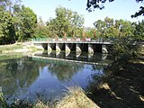
 The Boutonne at Saint-Jean-d'Angély | |
 | |
| Location | |
| Country | France |
| Physical characteristics | |
| Source | |
| - location | Chef-Boutonne |
| - coordinates | 46°06′46″N 00°03′57″W / 46.11278°N 0.06583°W |
| - elevation | 85 m (279 ft) |
| Mouth | |
| - location | Charente |
| - coordinates | 45°54′32″N 00°49′35″W / 45.90889°N 0.82639°W |
| - elevation | 4 m (13 ft) |
| Length | 98.8 km (61.4 mi) |
| Basin size | 1,320 km2 (510 sq mi) |
| Discharge | |
| - average | 13 m3/s (460 cu ft/s) |
Geography
changeThe Boutonne has a length of 98.8 km (61.4 mi), and a drainage basin with an area of approximately 1,327 km2 (512 sq mi).[1]
Its average yearly discharge (volume of water which passes through a section of the river per unit of time) is 5.50 m3/s (194 cu ft/s) at Saint-Séverin-sur-Boutonne in the Charente-Maritime department, at an altitude of 34 m (112 ft).[2]

Average monthly discharge (m3/s) at Saint-Séverin-sur-Boutonne (1969-2017)[2]
Course
changeThe Boutonne starts in the southeast of the Deux-Sèvres department, in the commune of Chef-Boutonne (that is, "Head of the Boutonne"), at an elevation of about 90 m (295 ft).[3]
It flows to the west and, later, to the southwest through the Deux-Sèvres and Charente-Maritime departments before flowing, at almost right angle, into the Charente river in Cabariot at about 4 m (13 ft) of altitude.[4]
The Boutonne flows through 1 region (Nouvelle-Aquitaine), 2 departments and 41 communes; they are, from source to mouth:[1]
- Deux-Sèvres: Chef-Boutonne (here is the source of the river), Fontenille-Saint-Martin-d'Entraigues, Chérigné, Lusseray, Brioux-sur-Boutonne, Vernoux-sur-Boutonne, Séligné, Brieuil-sur-Chizé, Villefollet, Villiers-sur-Chizé, Chizé, Le Vert (the last commune of Deux-Sèvres in the course of the river).
- Charente-Maritime: Dampierre-sur-Boutonne (the first commune where the Boutonne gets into the department), Saint-Séverin-sur-Boutonne, Coivert, Blanzay-sur-Boutonne, Saint-Georges-de-Longuepierre, Saint-Martial, Saint-Pierre-de-l'Isle, Nuaillé-sur-Boutonne, Saint-Pardoult, Les Églises-d'Argenteuil, Antezant-la-Chapelle, Vervant, Poursay-Garnaud, Courcelles, Saint-Julien-de-l'Escap, Saint-Jean-d'Angély (main city in the course of the river), Ternant, La Vergne, Voissay, Torxé, Les Nouillers, Tonnay-Boutonne, Puy-du-Lac, Archingeay, Saint-Coutant-le-Grand, Champdolent, Lussant, Cabariot (place where the river flows into the Charente river).
Seven communes have the name of the river in their names: Chef-Boutonne, Saint-Séverin-sur-Boutonne, Dampierre-sur-Boutonne, Tonnay-Boutonne, Blanzay-sur-Boutonne, Nuaillé-sur-Boutonne, Vernoux-sur-Boutonne.
Main tributaries
changeThe main tributaries of the Boutonne river are:[1]
|
Left tributaries:
|
|
Right tributaries:
|
Gallery
change-
 Bridge over the Boutonne in Bel-Ébat.
 -
 Bridge in Tonnay-Boutonne.
 -
 The Boutonne flowing through Dampierre-sur-Boutonne.


Related pages
changeReferences
change- ↑ 1.0 1.1 1.2 "La Boutonne (R6--0250)" (in French). SANDRE - Portail national d'accès aux référentiels sur l'eau. Retrieved 29 May 2017.
- ↑ 2.0 2.1 "La Boutonne à Saint-Séverin-sur-Boutonne [Moulin de Châtre]" (in French). Banque Hydro. Archived from the original on 3 March 2016. Retrieved 29 May 2017.
{{cite web}}: More than one of|archivedate=and|archive-date=specified (help); More than one of|archiveurl=and|archive-url=specified (help) - ↑ "Source de la Boutonne" (in French). Géoportail. Retrieved 29 May 2017.
- ↑ "Confluence de la Boutonne" (in French). Géoportail. Retrieved 29 May 2017.
Other websites
change- Banque Hydro - Station R6092920 - La Boutonne à Saint-Séverin-sur-Boutonne Archived 2015-02-19 at the Wayback Machine (in French)