Chūō, Tokyo
special ward in the Tokyo Metropolis in Japan
Chūō (中央区, Chūō-ku) is one of the 23 special wards of Tokyo, Japan.[1]
Chūō
中央区 | |
|---|---|
| Chūō City | |
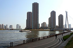
 Skyline of Chūō Ward by Sumida River | |
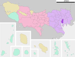
 Location of Chūō in Tokyo Metropolis | |
| Coordinates: 35°40′N 139°46′E / 35.667°N 139.767°E | |
| Country | Japan |
| Region | Kantō |
| Prefecture | Tokyo Metropolis |
| Government | |
| • Mayor | Taito Yamamoto |
| Area | |
| • Total | 10.21 km2 (3.94 sq mi) |
| Population (May 1, 2015) | |
| • Total | 141,454 |
| • Density | 13,850/km2 (35,900/sq mi) |
| Symbols | |
| • Tree | Willow |
| • Flower | Azalea |
| Time zone | UTC+9 (Japan Standard Time) |
| City hall address | Tsukiji 1-1-1 Chuo-ku, Tokyo 104-8404 |
| Website | www |
The municipality calls itself "Chūō City" in English.[2]
History
changeOn March 15, 1947, the ward was formed by combining the wards of Kyōbashi and Nihonbashi.[3]
Geography
changeChūō is in central Tokyo. It borders Tokyo Bay on the south. Minato is on the ward's southwestern border. Chiyoda is on the northwestern border. Sumida and Kōtō are on the east.
The most famous districts in Chūō are Ginza and Nihonbashi. Other districtsare Kabutochō and Tsukiji.[4]
In area, Chūō is the second-smallest ward in Tokyo. Only Taitō is smaller.
Related pages
changeReferences
change- ↑ Tokyo Metropolitan Government (TMG), "Municipalities within Tokyo" Archived 2012-03-28 at the Wayback Machine; retrieved 2012-3-30.
- ↑ "Chuo City 2009 Municipal Overview" Archived 2012-04-20 at the Wayback Machine; retrieved 2012-3-30.
- ↑ 大東京35区物語~15区から23区へ~東京23区の歴史 (in Japanese). Tokyo Metropolitan Archives. Archived from the original on 2020-06-17. Retrieved 2020-08-03.
- ↑ Nussbaum, Louis-Frédéric. (2005). "Chūō" in Japan Encyclopedia, p. 128.
Other websites
changeWikimedia Commons has media related to Chuo, Tokyo.
- http://www.city.chuo.lg.jp/foreign/english/index.html Archived 2009-07-08 at the Wayback Machine, (in Japanese)
- Chuo City Tourism Association, http://www.chuo-kanko.or.jp/english/index.html Archived 2012-06-18 at the Wayback Machine, (in Japanese)
- Tokyo Metropolitan Government, Special wardsArchived 2012-03-25 at the Wayback Machine


