File:Athabasca Oil Sands map.png

Size of this preview: 410 × 599 pixels. Other resolutions: 164 × 240 pixels | 328 × 480 pixels | 526 × 768 pixels | 1,200 × 1,753 pixels.
Original file (1,200 × 1,753 pixels, file size: 611 KB, MIME type: image/png)
| This is a file from the Wikimedia Commons. Information from its description page there is shown below. Commons is a freely licensed media file repository. You can help. |
Summary
| Description |
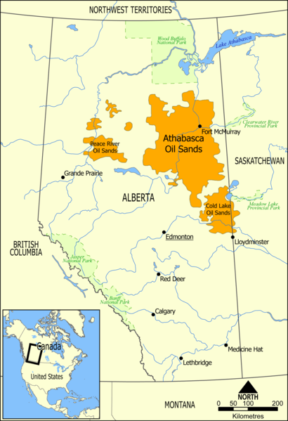
English: This map shows the extent of the oil sands in Alberta, Canada. The three oil sand deposits are known as the Athabasca Oil Sands, the Cold Lake Oil Sands, and the Peace River Oil Sands. |
| Date | |
| Source | Own work |
| Author | NormanEinstein |
| Other versions |
Derivative works of this file: Athabasca oil sand mining map 2011.jpg: |
Licensing
| I, the copyright holder of this work, release this work into the public domain. This applies worldwide. In some countries this may not be legally possible; if so: I grant anyone the right to use this work for any purpose, without any conditions, unless such conditions are required by law. |
File history
Click on a date/time to view the file as it appeared at that time.
| Date/Time | Thumbnail | Dimensions | User | Comment | |
|---|---|---|---|---|---|
| current | 16:49, 10 May 2006 | | 1,200 × 1,753 (611 KB) | NormanEinstein | This map shows the extent of the oils sands in Alberta, Canada. The three oil sand deposits are known as the Athabasca Oil Sands, the Cold Lake Oil Sands, and the Peace River Oil Sands. Created by NormanEinstein, May 10, 2006. {{GFDL-self}} [[Category: |
File usage
The following page uses this file:
Global file usage
The following other wikis use this file:
- Usage on ar.wikipedia.org
- Usage on bg.wikipedia.org
- Usage on ca.wikipedia.org
- Usage on cs.wikipedia.org
- Usage on da.wikipedia.org
- Usage on de.wikipedia.org
- Usage on el.wikipedia.org
- Usage on en.wikipedia.org
- Ernest Manning
- Oil sands
- Athabasca oil sands
- User:NormanEinstein/gallery
- Template:Text-superimpose
- Wabasca oil field
- History of the petroleum industry in Canada (oil sands and heavy oil)
- Kearl Oil Sands Project
- Cold Lake oil sands
- Peace River oil sands
- Oil sands tailings ponds (Canada)
- Tar Sands Healing Walk
- User:Klausronjaen/sandbox
- Georg Naumann
- User:Garrett.Nielsen/sandbox
- Environmental issues in Alberta
- Timeline of the petroleum industry in Alberta
- Template:Text-superimpose/doc
- Template:Text-superimpose/sandbox
- History of the Petroleum industry in Alberta
- Legacy pollution
- User:Spencerladner/Legacy pollution
- Usage on en.wikinews.org
- Usage on es.wikipedia.org
- Usage on fa.wikipedia.org
- Usage on fi.wikipedia.org
- Usage on fr.wikipedia.org
- Usage on gl.wikipedia.org
- Usage on he.wikipedia.org
- Usage on it.wikipedia.org
- Usage on ja.wikipedia.org
View more global usage of this file.