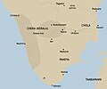
File:Chera country (early historic south India).jpg

Original file (2,670 × 2,219 pixels, file size: 878 KB, MIME type: image/jpeg)

Summary

Description
English: An approximate representation of the extent of Chera country in early historic south India
  • Source: 'Antecedents of the State Formation in Early South India' by Rajan Gurukkal in State and society in pre-modern South India
Date
Source Own work
Author Adapted from the maps by Y. Subbarayalu for Rajan Gurukkal
Other versions
This map image could be re-created using vector graphics as an SVG file. This has several advantages; see Commons:Media for cleanup for more information. If an SVG form of this image is available, please upload it and afterwards replace this template with {{vector version available|new image name}}.


It is recommended to name the SVG file “Chera country (early historic south India).svg”—then the template Vector version available (or Vva) does not need the new image name parameter.

Licensing

I, the copyright holder of this work, hereby publish it under the following license:
w:en:Creative Commons
attribution share alike
This file is licensed under the Creative Commons Attribution-Share Alike 4.0 International license.
You are free:
  • to share – to copy, distribute and transmit the work
  • to remix – to adapt the work
Under the following conditions:
  • attribution – You must give appropriate credit, provide a link to the license, and indicate if changes were made. You may do so in any reasonable manner, but not in any way that suggests the licensor endorses you or your use.
  • share alike – If you remix, transform, or build upon the material, you must distribute your contributions under the same or compatible license as the original.

Captions

Approximate representation of the extent of Chera Kingdom

Items portrayed in this file

depicts

8 July 2019

image/jpeg

1bdff91b653e10a00139e94b95a454f048a22a7f

899,241 byte

2,219 pixel

2,670 pixel

File history

Click on a date/time to view the file as it appeared at that time.

Date/TimeThumbnailDimensionsUserComment
current05:45, 20 March 2020Thumbnail for version as of 05:45, 20 March 20202,670 × 2,219 (878 KB)StephenPaaAdded terrain
13:45, 4 February 2020Thumbnail for version as of 13:45, 4 February 20202,670 × 2,219 (775 KB)StephenPaaAdded boundaries from ''State and Society in Pre-modern South India'' (Rajan Gurukkal)
02:19, 9 July 2019Thumbnail for version as of 02:19, 9 July 20192,000 × 1,333 (176 KB)TimdwilliamsonUser created page with UploadWizard

The following page uses this file:

Global file usage

The following other wikis use this file:

Metadata