File:China-Special Administrative Regions.png
No higher resolution available.
China-Special_Administrative_Regions.png (400 × 202 pixels, file size: 47 KB, MIME type: image/png)
| This is a file from the Wikimedia Commons. Information from its description page there is shown below. Commons is a freely licensed media file repository. You can help. |

|
This map image could be re-created using vector graphics as an SVG file. This has several advantages; see Commons:Media for cleanup for more information. If an SVG form of this image is available, please upload it and afterwards replace this template with
{{vector version available|new image name}}.
It is recommended to name the SVG file “China-Special Administrative Regions.svg”—then the template Vector version available (or Vva) does not need the new image name parameter. |
Summary
| Description |
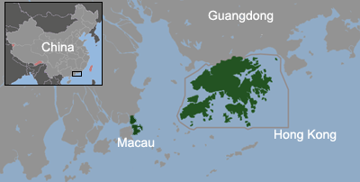
English: The location of SARs within the Pearl River Delta The map also shows the maritime boundary of Hong Kong since July 1 1997 and Macau since December 20, 1999 .
Español: Localización de las RR.AA.EE. en el Delta del Río Perla. El mapa muestra los límetes marítimos de Hong Kong desde 1-6-1997 y de Macao 20-12-1999. |
||||||||
| Date | |||||||||
| Source | Previously based on en:File:Image-Special Administrative Region of the People's Republic of China.png | ||||||||
| Author | Alanmak, Serg!o, ASDFGH | ||||||||
| Permission (Reusing this file) |
|
||||||||
| Other versions | Derivative works of this file: China-Special Administrative Regions-fr.png |

File history
Click on a date/time to view the file as it appeared at that time.
| Date/Time | Thumbnail | Dimensions | User | Comment | |
|---|---|---|---|---|---|
| current | 01:11, 22 June 2011 | | 400 × 202 (47 KB) | ASDFGH | add Macau Airport |
| 00:11, 20 October 2009 |  | 400 × 202 (42 KB) | Serg!o | {{Information |Description={{en|The location of SARs within the Pearl River Delta The map also shows the maritime boundary of Hong Kong since July 1 1997 and Macau since December 20, 1999 .}} {{es|Localización de las RR.AA.EE. en el Delta del Río Perla |
File usage
The following page uses this file:
Global file usage
The following other wikis use this file:
- Usage on azb.wikipedia.org
- Usage on bh.wikipedia.org
- Usage on ca.wikipedia.org
- Usage on cs.wikipedia.org
- Usage on en.wikipedia.org
- Usage on es.wikipedia.org
- Usage on fa.wikipedia.org
- Usage on fi.wikipedia.org
- Usage on fr.wikipedia.org
- Usage on he.wikipedia.org
- Usage on hi.wikipedia.org
- Usage on hu.wikipedia.org
- Usage on ka.wikipedia.org
- Usage on lmo.wikipedia.org
- Usage on no.wikipedia.org
- Usage on ps.wikipedia.org
- Usage on pt.wikipedia.org
- Usage on ro.wikipedia.org
- Usage on sk.wikipedia.org
- Usage on th.wikipedia.org
- Usage on uk.wikipedia.org
- Usage on ur.wikipedia.org
- Usage on vi.wikipedia.org
- Usage on zh.wikipedia.org