File:Clinton Lake map.jpg
No higher resolution available.
Clinton_Lake_map.jpg (600 × 427 pixels, file size: 254 KB, MIME type: image/jpeg)
| This is a file from the Wikimedia Commons. Information from its description page there is shown below. Commons is a freely licensed media file repository. You can help. |
Summary
| Description |
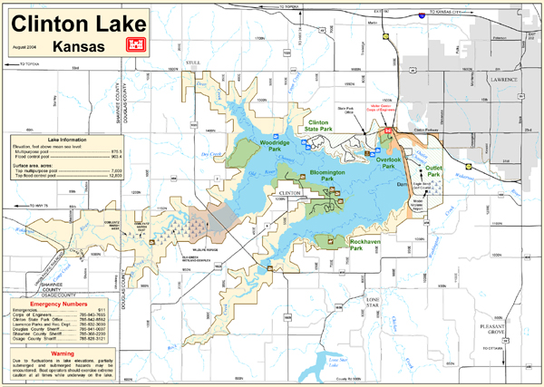
English: This is a USACE map of the Clinton Lake area in Lawrence, Kansas. It was retrieved from the US Army Corps of Engineers page at: http://www.nwk.usace.army.mil/clinton/clin.html. |
| Date | 13 October 2004 (according to Exif data) |
| Source | Own work by the original uploader |
| Author |
Licensing
This image or file is a work of a U.S. Army Corps of Engineers soldier or employee, taken or made as part of that person's official duties. As a work of the U.S. federal government, the image is in the public domain.
|
Original upload log
Transferred from en.wikipedia to Commons using For the Common Good.
The original description page was here. All following user names refer to en.wikipedia.
| Date/Time | Dimensions | User | Comment |
|---|---|---|---|
| 15:08, 13 April 2006 | 600 × 427 (259,930 bytes) | w:en:CharacterZero (talk | contribs) | This is a map of the Clinton Lake area in Lawrence, Kansas. It was retrieved from the US Army Corps of Engineers page at: http://www.nwk.usace.army.mil/clinton/clin.html. |
File history
Click on a date/time to view the file as it appeared at that time.
| Date/Time | Thumbnail | Dimensions | User | Comment | |
|---|---|---|---|---|---|
| current | 03:37, 8 January 2018 | | 600 × 427 (254 KB) | Illegitimate Barrister | Transferred from en.wikipedia: see original upload log above |
File usage
The following page uses this file:
Global file usage
The following other wikis use this file:
- Usage on en.wikipedia.org
- Usage on fr.wikipedia.org
- Usage on it.wikipedia.org