File:Flooding after Bento Rodrigues dam breach.gif
Size of this preview: 800 × 450 pixels. Other resolutions: 320 × 180 pixels | 825 × 464 pixels.
Original file (825 × 464 pixels, file size: 728 KB, MIME type: image/gif, looped, 2 frames, 2.5 s)
| This is a file from the Wikimedia Commons. Information from its description page there is shown below. Commons is a freely licensed media file repository. You can help. |
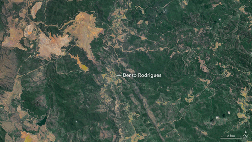
Summary
| Description |
English: Flooding after dam breach in Bento Rodrigues (Brasil)
Português: Rompimento de barragens em Bento Rodrigues (Brasil) |
| Date | |
| Source | http://earthobservatory.nasa.gov/IOTD/view.php?id=86990 |
| Author | NASA |
| Camera location | | View this and other nearby images on: OpenStreetMap |
|---|
Licensing
| This file is in the public domain in the United States because it was solely created by NASA. NASA copyright policy states that "NASA material is not protected by copyright unless noted". (See Template:PD-USGov, NASA copyright policy page or JPL Image Use Policy.) | ||
 |
Warnings:
|
File history
Click on a date/time to view the file as it appeared at that time.
| Date/Time | Thumbnail | Dimensions | User | Comment | |
|---|---|---|---|---|---|
| current | 12:58, 18 November 2015 | | 825 × 464 (728 KB) | Holapaco77 | {{Information |Description ={{en|1=Flooding after dam breach in Bento Rodrigues (Brasil)}} {{pt-br|1=Rompimento de barragens em Bento Rodrigues (Brasil)}} |Source =http://earthobservatory.nasa.gov/IOTD/view.php?id=86990 |Author =[[NA... |
File usage
The following page uses this file:
Global file usage
The following other wikis use this file:
- Usage on ast.wikipedia.org
- Usage on de.wikipedia.org
- Usage on en.wikipedia.org
- Usage on es.wikipedia.org
- Usage on fi.wikipedia.org
- Usage on fr.wikipedia.org
- Usage on gl.wikipedia.org
- Usage on it.wikipedia.org
- Usage on pt.wikipedia.org
- Usage on sr.wikipedia.org
- Usage on zh.wikipedia.org