File:Golan Heights relief v2.png

Size of this preview: 522 × 600 pixels. Other resolutions: 209 × 240 pixels | 418 × 480 pixels | 758 × 871 pixels.
Original file (758 × 871 pixels, file size: 923 KB, MIME type: image/png)
| This is a file from the Wikimedia Commons. Information from its description page there is shown below. Commons is a freely licensed media file repository. You can help. |
Summary
| Description |
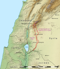
English: This is a shaded relief map illustrating the topography of the Golan Heights and surrounding areas. Transverse Mercator projection (EPSG: 2039) Source data: * Elevation data: SRTM data from NASA[1] * Borders, cities, and geographic features: The Natural Earth
العربية: هذه خريطة مجسمة مظللة توضح تضاريس هضبة الجولان والمناطق المحيطة بها ومآل مناطق النزاع على الحدود بين سوريا وإسرائيل. الإحداثيات حسب نظام إسقاط ميركاتور المستعرض (EPSG: 2039)
مصدر البيانات:
|
| Date | (UTC) |
| Source | |
| Author |
|
| Other versions | File:Golan Heights geography.png |

|
This map image could be re-created using vector graphics as an SVG file. This has several advantages; see Commons:Media for cleanup for more information. If an SVG form of this image is available, please upload it and afterwards replace this template with
{{vector version available|new image name}}.
It is recommended to name the SVG file “Golan Heights relief v2.svg”—then the template Vector version available (or Vva) does not need the new image name parameter. |
| This is a retouched picture, which means that it has been digitally altered from its original version. Modifications: Adjusted borders to prioritise internationally recognised borders.. The original can be viewed here: Golan Heights relief v1.jpg:
|
Licensing
I, the copyright holder of this work, hereby publish it under the following licenses:
This file is licensed under the Creative Commons Attribution-Share Alike 3.0 Unported license.
- You are free:
- to share – to copy, distribute and transmit the work
- to remix – to adapt the work
- Under the following conditions:
- attribution – You must give appropriate credit, provide a link to the license, and indicate if changes were made. You may do so in any reasonable manner, but not in any way that suggests the licensor endorses you or your use.
- share alike – If you remix, transform, or build upon the material, you must distribute your contributions under the same or compatible license as the original.

|
Permission is granted to copy, distribute and/or modify this document under the terms of the GNU Free Documentation License, Version 1.2 or any later version published by the Free Software Foundation; with no Invariant Sections, no Front-Cover Texts, and no Back-Cover Texts. A copy of the license is included in the section entitled GNU Free Documentation License. |
You may select the license of your choice.
Original upload log
This image is a derivative work of the following images:
- File:Golan_Heights_relief_v1.jpg licensed with Cc-by-sa-3.0, GFDL
- 2011-03-15T03:27:39Z Kbh3rd 758x871 (279344 Bytes) With "Golan Heights" labeled, from original layers to avoid quality issues with Chesdovi's edit
- 2011-03-09T15:33:27Z Chesdovi 615x605 (161970 Bytes) Adding GOLAN HEIGHTS wording
- 2011-01-24T03:44:15Z Kbh3rd 758x871 (278034 Bytes) {{Information |Description ={{en|1=This is a [[:en:shaded relief|shaded relief]] map illustrating the topography of the [[:en:Golan Heights|Golan Heights]] and surrounding areas. Transverse Mercator projection (EPSG: 2039
Uploaded with derivativeFX
File history
Click on a date/time to view the file as it appeared at that time.
| Date/Time | Thumbnail | Dimensions | User | Comment | |
|---|---|---|---|---|---|
| current | 06:27, 29 November 2011 | | 758 × 871 (923 KB) | Night w | == {{int:filedesc}} == {{Information |Description={{en|1=This is a shaded relief map illustrating the topography of the Golan Heights and surrounding areas. Transverse Mercator projection (EPSG: |
File usage
The following 3 pages use this file:
Global file usage
The following other wikis use this file:
- Usage on ar.wikipedia.org
- Usage on ca.wikipedia.org
- Usage on ceb.wikipedia.org
- Usage on de.wikipedia.org
- Usage on el.wikipedia.org
- Usage on en.wikipedia.org
- Usage on eo.wikipedia.org
- Usage on es.wikipedia.org
- Usage on eu.wikipedia.org
- Usage on fa.wikipedia.org
- Usage on fr.wikipedia.org
- Usage on hi.wikibooks.org
- Usage on hu.wikipedia.org
- Usage on hyw.wikipedia.org
- Usage on id.wikipedia.org
- Usage on it.wikipedia.org
- Usage on ja.wikipedia.org
- Usage on kn.wikipedia.org
- Usage on ml.wikipedia.org
- Usage on nl.wikipedia.org
- Usage on os.wikipedia.org
- Usage on pt.wikipedia.org
- Usage on ru.wikipedia.org
View more global usage of this file.