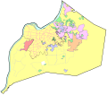
File:Jefferson County KY places.svg

Size of this PNG preview of this SVG file: 684 × 600 pixels. Other resolutions: 274 × 240 pixels | 548 × 480 pixels | 876 × 768 pixels | 1,168 × 1,024 pixels | 2,337 × 2,048 pixels | 1,911 × 1,675 pixels.
Original file (SVG file, nominally 1,911 × 1,675 pixels, file size: 144 KB)
File history
Click on a date/time to view the file as it appeared at that time.
| Date/Time | Thumbnail | Dimensions | User | Comment | |
|---|---|---|---|---|---|
| current | 11:21, 28 August 2009 |  | 1,911 × 1,675 (144 KB) | Lasunncty | missed area |
| 11:11, 28 August 2009 |  | 1,911 × 1,675 (144 KB) | Lasunncty | {{Information |Description={{en|1= Areas: *Yellow - 1st class (Louisville Metro) *Orange - 2nd class (Jeffersontown) *Red - 3rd class (Shively) *Magenta - 4th class *Blue - 5th class *Green - 6th class *Cyan - Ohio River Dotted outlines: *Purple - urban |
File usage
The following page uses this file:
Global file usage
The following other wikis use this file:
- Usage on arz.wikipedia.org
- Usage on de.wikipedia.org
- Usage on en.wikipedia.org
- Usage on ja.wikipedia.org
- Usage on pt.wikipedia.org
- Usage on vi.wikipedia.org
