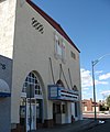
File:Needles, California (3226903381) (cropped).jpg

Original file (1,200 × 1,442 pixels, file size: 145 KB, MIME type: image/jpeg)
| This is a file from the Wikimedia Commons. Information from its description page there is shown below. Commons is a freely licensed media file repository. You can help. |
Summary
| DescriptionNeedles, California (3226903381) (cropped).jpg |
Needles is a city located on the western banks of the Colorado River in San Bernardino County, California. It is located in Mojave Valley, which straddles the California-Arizona border. The city is accessible via Interstate 40 and U.S. Route 95. The population was 4,830 at the 2000 census, and was estimated at 5,700 by mid-2008. Needles was named after "The Needles," a group of pointed rocks on the Arizona side of the river. There is a relatively large Mohave community, although they are not the majority. Mohave people had been living in the area for hundreds, if not thousands, of years prior to the European exploration of the area. In 1859, Fort Mojave was built to protect immigrants to California and other travelers from the Mohave. The city was founded in 1883 as a result of the construction of the railroad, which crosses the Colorado at this point. The name is derived from pointed mountain peaks at the south end of the valley. Historic U.S. Route 66 passes through the city, lined with motels and other shops from that era. Needles is a tourism and recreation center, a tradition going back for decades. Needles, like Death Valley, is known for extreme heat during the summers. Temperatures in Needles routinely reach 120 °F (49 °C) in late July and early August. The Needles weather station is frequently reported by the United State government's National Oceanic and Atmospheric Administration (NOAA) as the site of the highest daily temperature recorded in the U.S. during the hot desert summers. Needles occasionally sets national or world daily high temperature records. Major employment in the city is supported by the BNSF Railway (formerly the Santa Fe Railroad). The depot has been a terminal (crew change point) for the railway since the late 1800s. The railroad company has been the city's main employment source for over a century. <a href="http://en.wikipedia.org/wiki/Needles,_California" rel="noreferrer nofollow">en.wikipedia.org/wiki/Needles,_California</a> <a href="http://en.wikipedia.org/wiki/Wikipedia:Text_of_Creative_Commons_Attribution-ShareAlike_3.0_Unported_License" rel="noreferrer nofollow">en.wikipedia.org/wiki/Wikipedia:Text_of_Creative_Commons_...</a> |
|||
| Date | ||||
| Source | Needles, California | |||
| Author | Ken Lund from Reno, Nevada, USA | |||
| Other versions |
|
| Camera location | 34° 50′ 21″ N, 114° 36′ 20.81″ W | View this and other nearby images on: OpenStreetMap |
|---|
Licensing
- You are free:
- to share – to copy, distribute and transmit the work
- to remix – to adapt the work
- Under the following conditions:
- attribution – You must give appropriate credit, provide a link to the license, and indicate if changes were made. You may do so in any reasonable manner, but not in any way that suggests the licensor endorses you or your use.
- share alike – If you remix, transform, or build upon the material, you must distribute your contributions under the same or compatible license as the original.
Captions
Items portrayed in this file
depicts
25 January 2009
34°50'21.001"N, 114°36'20.808"W
0.0015625 second
5.8 millimetre
image/jpeg
File history
Click on a date/time to view the file as it appeared at that time.
| Date/Time | Thumbnail | Dimensions | User | Comment | |
|---|---|---|---|---|---|
| current | 17:44, 6 April 2022 |  | 1,200 × 1,442 (145 KB) | Cristiano Tomás | File:Needles, California (3226903381).jpg cropped 10 % vertically using CropTool with precise mode. |
File usage
The following page uses this file:
Global file usage
The following other wikis use this file:
- Usage on en.wikipedia.org
Metadata
This file contains additional information, probably added from the digital camera or scanner used to create or digitize it.
If the file has been modified from its original state, some details may not fully reflect the modified file.
| Camera manufacturer | Canon |
|---|---|
| Camera model | Canon PowerShot A540 |
| Exposure time | 1/640 sec (0.0015625) |
| F Number | f/4 |
| Date and time of data generation | 13:12, 25 January 2009 |
| Lens focal length | 5.8 mm |
| Orientation | Normal |
| Horizontal resolution | 180 dpi |
| Vertical resolution | 180 dpi |
| File change date and time | 13:12, 25 January 2009 |
| Y and C positioning | Centered |
| Exif version | 2.2 |
| Date and time of digitizing | 13:12, 25 January 2009 |
| Meaning of each component |
|
| Image compression mode | 5 |
| APEX shutter speed | 9.3125 |
| APEX aperture | 4 |
| APEX exposure bias | −0.33333333333333 |
| Maximum land aperture | 2.75 APEX (f/2.59) |
| Metering mode | Pattern |
| Flash | Flash did not fire, compulsory flash suppression, red-eye reduction mode |
| Supported Flashpix version | 1 |
| Color space | sRGB |
| Focal plane X resolution | 12,497.041420118 |
| Focal plane Y resolution | 12,515.555555556 |
| Focal plane resolution unit | inches |
| Sensing method | One-chip color area sensor |
| File source | Digital still camera |
| Custom image processing | Normal process |
| Exposure mode | Manual exposure |
| White balance | Auto white balance |
| Digital zoom ratio | 1 |
| Scene capture type | Landscape |
