File:Relief map Pacific Electric Railway.jpg

Size of this preview: 800 × 400 pixels. Other resolutions: 320 × 160 pixels | 640 × 320 pixels | 1,024 × 512 pixels | 1,280 × 640 pixels | 2,560 × 1,280 pixels | 6,432 × 3,216 pixels.
Original file (6,432 × 3,216 pixels, file size: 9.25 MB, MIME type: image/jpeg)
| This is a file from the Wikimedia Commons. Information from its description page there is shown below. Commons is a freely licensed media file repository. You can help. |
Summary
| Description |
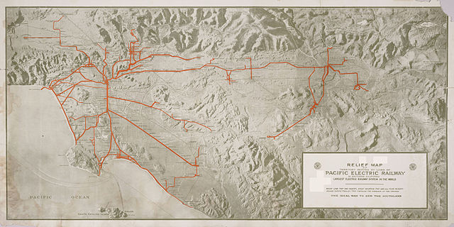
English: Relief map of territory served by lines of [the] Pacific Electric Railway in Southern California; largest electric railway system in the world
|
| Date | circa 1920 |
| Source | http://content.cdlib.org/ark:/13030/hb638nb72q/?layout=metadata |
| Author | Smith, O. A, Cartographer |
Licensing
This work is in the public domain in the United States because it is a work prepared by an officer or employee of the United States Government as part of that person’s official duties under the terms of Title 17, Chapter 1, Section 105 of the US Code.
Note: This only applies to original works of the Federal Government and not to the work of any individual U.S. state, territory, commonwealth, county, municipality, or any other subdivision. This template also does not apply to postage stamp designs published by the United States Postal Service since 1978. (See § 313.6(C)(1) of Compendium of U.S. Copyright Office Practices). It also does not apply to certain US coins; see The US Mint Terms of Use.
|
 | |
| This file has been identified as being free of known restrictions under copyright law, including all related and neighboring rights. | ||
File history
Click on a date/time to view the file as it appeared at that time.
| Date/Time | Thumbnail | Dimensions | User | Comment | |
|---|---|---|---|---|---|
| current | 01:27, 3 September 2014 | | 6,432 × 3,216 (9.25 MB) | Junkyardsparkle | Falling back to full/2 scale to unbreak thumbnail generation. |
| 01:08, 3 September 2014 |  | 12,864 × 6,432 (18.79 MB) | Junkyardsparkle | Full resolution. | |
| 23:11, 27 August 2014 |  | 2,400 × 1,200 (1.21 MB) | Junkyardsparkle | Higher resolution (names are legible at 1:1). | |
| 05:49, 24 June 2007 |  | 1,468 × 717 (188 KB) | Nopira | from en:Image:Relief map Pacific Electric Railway.jpg http://ark.cdlib.org/ark:/13030/hb638nb72q/ Category:Los Angeles, California |
File usage
The following page uses this file:
Global file usage
The following other wikis use this file:
- Usage on en.wikipedia.org
- Usage on fr.wikipedia.org
- Usage on ja.wikipedia.org
- Usage on www.wikidata.org
- Usage on zh.wikipedia.org