File:Royal-geographical-society geographical-journal 1914 macquarie-island-antarctica 1381 2000 600.jpg

Size of this preview: 429 × 599 pixels. Other resolutions: 172 × 240 pixels | 344 × 480 pixels | 550 × 768 pixels | 733 × 1,024 pixels | 2,000 × 2,792 pixels.
Original file (2,000 × 2,792 pixels, file size: 610 KB, MIME type: image/jpeg)
| This is a file from the Wikimedia Commons. Information from its description page there is shown below. Commons is a freely licensed media file repository. You can help. |
Summary
| Description |
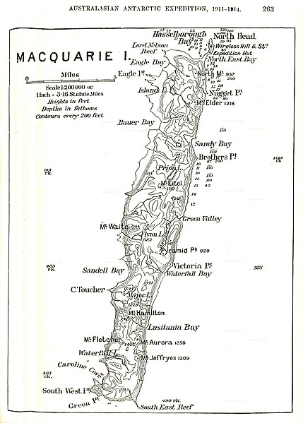
English: old map of Macquarie Island, Tasmania, Australia |
| Date | |
| Source | http://www.hipkiss.org/data/maps/royal-geographical-society_geographical-journal_1914_macquarie-island-antarctica_1381_2000_600.jpg |
| Author | Unknown author |
Licensing
This work is in the public domain in the United States because it was published (or registered with the U.S. Copyright Office) before January 1, 1929.
|
This image or other work is of Australian origin and is now in the public domain because its term of copyright has expired. According to the Australian Copyright Council (ACC), ACC Information Sheet G023v19 (Duration of copyright) (January 2019).1
When using this template, please provide information of where the image was first published and who created it. |
 | |||||||||||||||||||
First published in Douglas Mawson's Home of the Blizzard 1914
File history
Click on a date/time to view the file as it appeared at that time.
| Date/Time | Thumbnail | Dimensions | User | Comment | |
|---|---|---|---|---|---|
| current | 19:40, 16 November 2020 | | 2,000 × 2,792 (610 KB) | CSvBibra | sharpen, reduce distortion, contrast |
| 11:10, 20 September 2011 |  | 1,381 × 2,000 (293 KB) | Ratzer | {{Information |Description ={{en|1=old map of Macquarie Island, Tasmania, Australia}} |Source =http://www.hipkiss.org/data/maps/royal-geographical-society_geographical-journal_1914_macquarie-island-antarctica_1381_2000_600.jpg |Author = |
File usage
The following page uses this file:
Global file usage
The following other wikis use this file:
- Usage on de.wikipedia.org
- Usage on et.wikipedia.org
- Usage on fa.wikipedia.org
- Usage on frr.wikipedia.org
- Usage on fr.wikipedia.org
- Usage on hu.wikipedia.org
- Usage on ja.wikipedia.org
- Usage on mrj.wikipedia.org
- Usage on nn.wikipedia.org
- Usage on pt.wikipedia.org
- Usage on ru.wikipedia.org
- Usage on tr.wikipedia.org
- Usage on vi.wikipedia.org