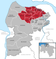
File:Samtgemeinde Land Hadeln in CUX.svg

Size of this PNG preview of this SVG file: 568 × 600 pixels. Other resolutions: 227 × 240 pixels | 455 × 480 pixels | 727 × 768 pixels | 970 × 1,024 pixels | 1,940 × 2,048 pixels | 1,771 × 1,870 pixels.
Original file (SVG file, nominally 1,771 × 1,870 pixels, file size: 457 KB)
File history
Click on a date/time to view the file as it appeared at that time.
| Date/Time | Thumbnail | Dimensions | User | Comment | |
|---|---|---|---|---|---|
| current | 17:51, 31 October 2016 |  | 1,771 × 1,870 (457 KB) | NordNordWest | upd |
| 15:42, 2 January 2015 |  | 1,771 × 1,870 (457 KB) | NordNordWest | upd | |
| 16:11, 1 January 2014 |  | 1,771 × 1,870 (626 KB) | NordNordWest | upd | |
| 08:09, 2 November 2011 |  | 1,771 × 1,870 (652 KB) | WiebkeCBo | incorporation of Appeln, Bokel, Frelsdorf, Heerstedt, Hollen, Kirchwistedt, Lunestedt and Stubben into Beverstedt | |
| 09:40, 10 December 2010 |  | 1,771 × 1,870 (1.09 MB) | WiebkeCBo | == {{int:filedesc}} == {{Information |Description= {{DeLocMaps |mun=Samtgemeinde Land Hadeln |munlink= |lk=Landkreis Cuxhaven |enlk=District of Cuxhaven |enlklink=Cuxhaven (district) |frlk=L'arrondissement de Cuxhaven |frlklink=Arrondissement de Cuxhaven |
File usage
The following page uses this file:
Global file usage
The following other wikis use this file:
- Usage on da.wikipedia.org
- Usage on de.wikipedia.org
- Usage on en.wikipedia.org
- Usage on eo.wikipedia.org
- Usage on et.wikipedia.org
- Usage on it.wikipedia.org
- Usage on ja.wikipedia.org
- Usage on nds.wikipedia.org
- Usage on nl.wikipedia.org
- Usage on pl.wikipedia.org
- Usage on ru.wikipedia.org
- Usage on www.wikidata.org


