File:Sorex palustris distribution.svg

Size of this PNG preview of this SVG file: 515 × 599 pixels. Other resolutions: 206 × 240 pixels | 412 × 480 pixels | 660 × 768 pixels | 880 × 1,024 pixels | 1,760 × 2,048 pixels | 1,712 × 1,992 pixels.
Original file (SVG file, nominally 1,712 × 1,992 pixels, file size: 240 KB)
| This is a file from the Wikimedia Commons. Information from its description page there is shown below. Commons is a freely licensed media file repository. You can help. |
| Description |
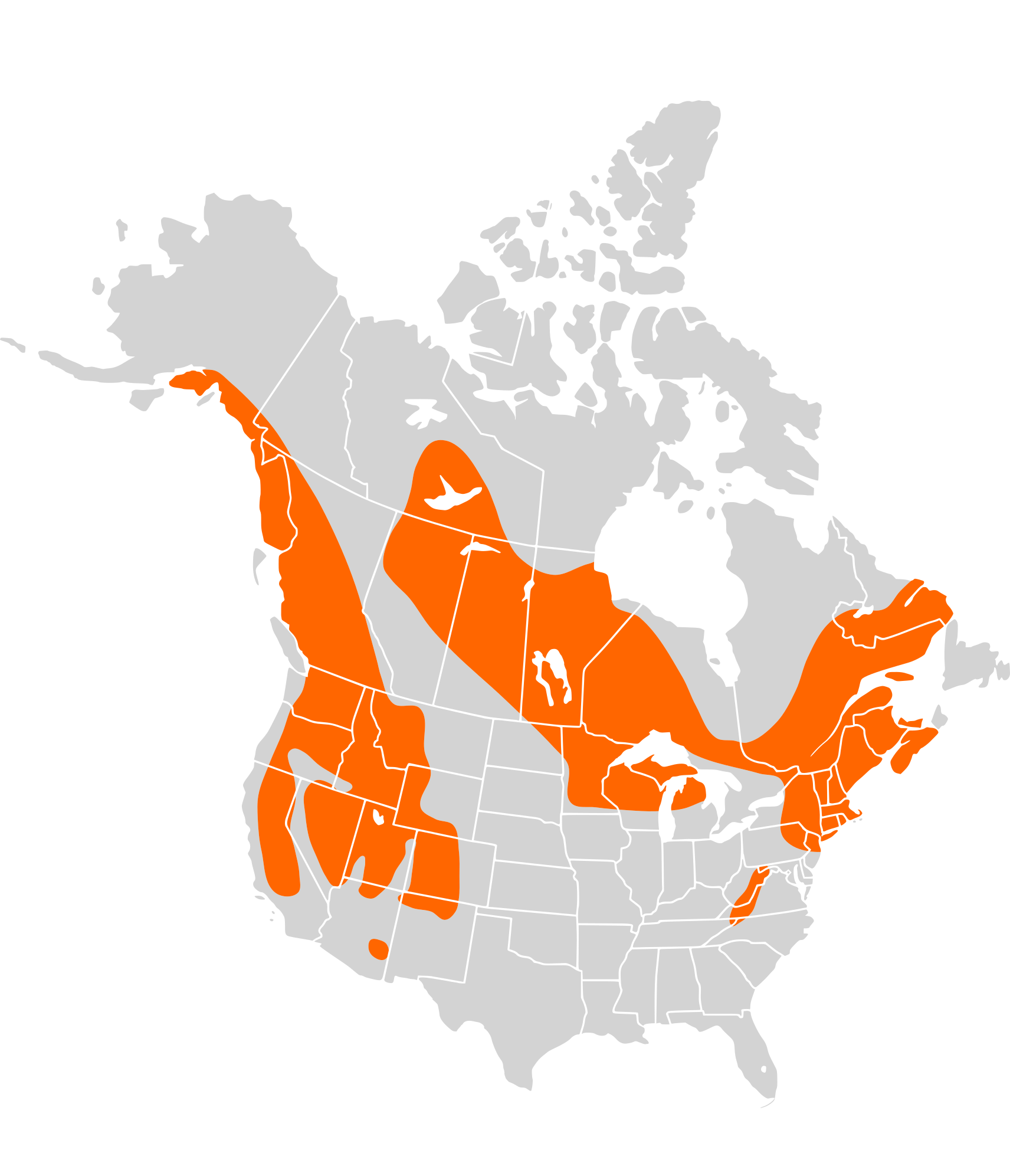
English: Distribution of the American Water Shrew (Sorex palustris) with http://www.mnh.si.edu/mna/thumbnails/maps/322.gif
Français : Distribution de la Musaraigne palustre (Sorex palustris) à partir de http://www.mnh.si.edu/mna/thumbnails/maps/322.gif
W3C-validity not checked. |
| Date | (UTC) |
| Source | |
| Author |
|
| This is a retouched picture, which means that it has been digitally altered from its original version. The original can be viewed here: North America second level political division 2.svg:
|
I, the copyright holder of this work, hereby publish it under the following license:
This file is licensed under the Creative Commons Attribution-Share Alike 2.5 Generic license.
- You are free:
- to share – to copy, distribute and transmit the work
- to remix – to adapt the work
- Under the following conditions:
- attribution – You must give appropriate credit, provide a link to the license, and indicate if changes were made. You may do so in any reasonable manner, but not in any way that suggests the licensor endorses you or your use.
- share alike – If you remix, transform, or build upon the material, you must distribute your contributions under the same or compatible license as the original.
Original upload log
This image is a derivative work of the following images:
- File:North_America_second_level_political_division_2.svg licensed with Cc-by-sa-2.5
- 2007-12-08T23:23:36Z Lokal Profil 1712x1992 (335351 Bytes) Code cleanup
- 2007-10-07T07:55:13Z AlexCovarrubias 1712x1992 (350437 Bytes) == Summary == {{Information |Description=Map of North America and its second-level political divisions. Canadian provinces, US and Mexican states. Canada, Mexico, United States. |Source=Canada and US map by Alan Rockefeller.
Uploaded with derivativeFX
File history
Click on a date/time to view the file as it appeared at that time.
| Date/Time | Thumbnail | Dimensions | User | Comment | |
|---|---|---|---|---|---|
| current | 17:08, 31 January 2010 | | 1,712 × 1,992 (240 KB) | Totodu74 | {{Information |Description={{en|Map of North America and its second-level political divisions. Canadian provinces, US and Mexican states. Canada, Mexico, United States. Non-contiguous parts of a states/provinces are "grouped" together with the main area |
File usage
The following page uses this file:
Global file usage
The following other wikis use this file:
- Usage on ar.wikipedia.org
- Usage on avk.wikipedia.org
- Usage on ceb.wikipedia.org
- Usage on de.wikipedia.org
- Usage on en.wikipedia.org
- Usage on fr.wikipedia.org
- Usage on he.wikipedia.org
- Usage on is.wikipedia.org
- Usage on nl.wikipedia.org
- Usage on nv.wikipedia.org
- Usage on pt.wikipedia.org
- Usage on ru.wikipedia.org
- Usage on sv.wikipedia.org
- Usage on uk.wikipedia.org
- Usage on vi.wikipedia.org