File:Struthio camelus distribution.svg

Size of this PNG preview of this SVG file: 588 × 600 pixels. Other resolutions: 235 × 240 pixels | 470 × 480 pixels | 753 × 768 pixels | 1,004 × 1,024 pixels | 2,007 × 2,048 pixels | 687 × 701 pixels.
Original file (SVG file, nominally 687 × 701 pixels, file size: 778 KB)
| This is a file from the Wikimedia Commons. Information from its description page there is shown below. Commons is a freely licensed media file repository. You can help. |
Summary
| Description |
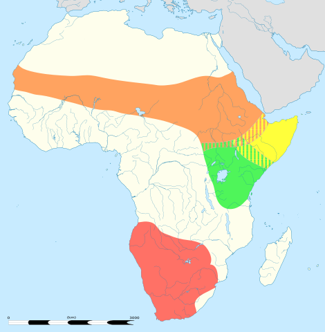
English: An updated version to reflect the correct Southern African distribution as per Sasol Birds of Southern Africa (2011) |
| Date |
English: Blank administrative map of political Africa as in 2011-07, for geo-location purposes. On English Wikipedia, in "Template:Location_map_Africa" to set marker along curved latitude/longitude lines. Français : Carte administrative vierge de l'Afrique politique telle qu'en 07/2011, destinée à la géolocalisation. En Wikipédia Francais, a la Modèle:Géolocalisation/Afrique pour carte avec marqueur-image. A Lambert azimuthal equal-area projection, WGS84 datum *Standard meridian: 15°E *Standard parallel: 0° Scale: 1:23,420,000 (precision: 5,855 km) |
| Source |
This file was derived from: |
| Author |
|
| Other versions | There is a version of this map with key and legends included in the graphic at File:Struthio camelus distribution with key.svg |

| This is a retouched picture, which means that it has been digitally altered from its original version. Modifications: redrawn/vectorised/combined. The original can be viewed here: Africa location map.svg:
|
Licensing
This file is licensed under the Creative Commons Attribution-Share Alike 3.0 Unported license.
- You are free:
- to share – to copy, distribute and transmit the work
- to remix – to adapt the work
- Under the following conditions:
- attribution – You must give appropriate credit, provide a link to the license, and indicate if changes were made. You may do so in any reasonable manner, but not in any way that suggests the licensor endorses you or your use.
- share alike – If you remix, transform, or build upon the material, you must distribute your contributions under the same or compatible license as the original.
Original upload log
This image is a derivative work of the following images:
- File:Struthio_camelus_Distribution_updated.png licensed with Cc-by-sa-3.0
- 2012-09-26T13:18:50Z Metatronx 1038x1270 (28425 Bytes) User created page with UploadWizard
- File:Africa_location_map.svg licensed with Cc-by-sa-3.0, GFDL
- 2012-10-02T12:40:15Z Palosirkka 1525x1440 (792744 Bytes) Reverted to version as of 19:13, 14 July 2011 Location maps must remain very accurate
- 2012-09-12T20:15:41Z Palosirkka 1525x1440 (537042 Bytes) Scrubbed with http://codedread.com/scour/
- 2011-07-14T19:13:55Z Sting 1525x1440 (792744 Bytes) Sudan/South Sudan 2011-07 border update
- 2010-07-02T20:12:15Z Sting 1525x1440 (586394 Bytes) == {{int:filedesc}} == {{Location|00|00|00|N|15|00|00|E|scale:30000000}} {{Information |Description={{en|Blank administrative map of political [[:en:Africa|Africa]], for geo-location purposes.}} {{fr|Carte administrative vier
Uploaded with derivativeFX
File history
Click on a date/time to view the file as it appeared at that time.
| Date/Time | Thumbnail | Dimensions | User | Comment | |
|---|---|---|---|---|---|
| current | 05:06, 22 August 2013 | | 687 × 701 (778 KB) | Begoon | position/keyline |
| 18:41, 21 August 2013 |  | 687 × 701 (902 KB) | Begoon | and re-crop | |
| 18:22, 21 August 2013 |  | 750 × 705 (901 KB) | Begoon | no legend | |
| 18:07, 21 August 2013 |  | 750 × 705 (932 KB) | Begoon | nah - better how it was | |
| 18:02, 21 August 2013 |  | 750 × 705 (932 KB) | Begoon | reduce legend size | |
| 16:06, 21 August 2013 |  | 750 × 705 (932 KB) | Begoon | tweak - square up legend key blocks after resize | |
| 15:41, 21 August 2013 |  | 750 × 705 (931 KB) | Begoon | shading | |
| 14:31, 21 August 2013 |  | 750 × 705 (914 KB) | Begoon | clearer colours for infobox | |
| 13:11, 21 August 2013 |  | 750 × 705 (919 KB) | Begoon | reduce yellow in land colour to increase yellow distrib area contrast | |
| 12:16, 21 August 2013 |  | 750 × 705 (919 KB) | Begoon | oops - fix crop properly |
File usage
The following page uses this file:
Global file usage
The following other wikis use this file:
- Usage on af.wikipedia.org
- Usage on am.wikipedia.org
- Usage on ar.wikipedia.org
- Usage on azb.wikipedia.org
- Usage on ba.wikipedia.org
- Usage on cs.wikipedia.org
- Usage on de.wikipedia.org
- Usage on en.wikipedia.org
- Usage on es.wikipedia.org
- Usage on gl.wikipedia.org
- Usage on ilo.wikipedia.org
- Usage on is.wikipedia.org
- Usage on it.wikipedia.org
- Usage on kn.wikipedia.org
- Usage on kw.wikipedia.org
- Usage on lt.wikipedia.org
- Usage on mk.wikipedia.org
- Usage on ms.wikipedia.org
- Usage on my.wikipedia.org
- Usage on pa.wikipedia.org
- Usage on pl.wikipedia.org
- Usage on pt.wikipedia.org
- Usage on ru.wikipedia.org
- Usage on sco.wikipedia.org
- Usage on sl.wikipedia.org
- Usage on tr.wikipedia.org
- Usage on vi.wikipedia.org
- Usage on wa.wikipedia.org