File:Uebersicht-RD.png
Size of this preview: 495 × 599 pixels. Other resolutions: 198 × 240 pixels | 396 × 480 pixels | 950 × 1,150 pixels.
Original file (950 × 1,150 pixels, file size: 56 KB, MIME type: image/png)
| This is a file from the Wikimedia Commons. Information from its description page there is shown below. Commons is a freely licensed media file repository. You can help. |
Summary
| Description |
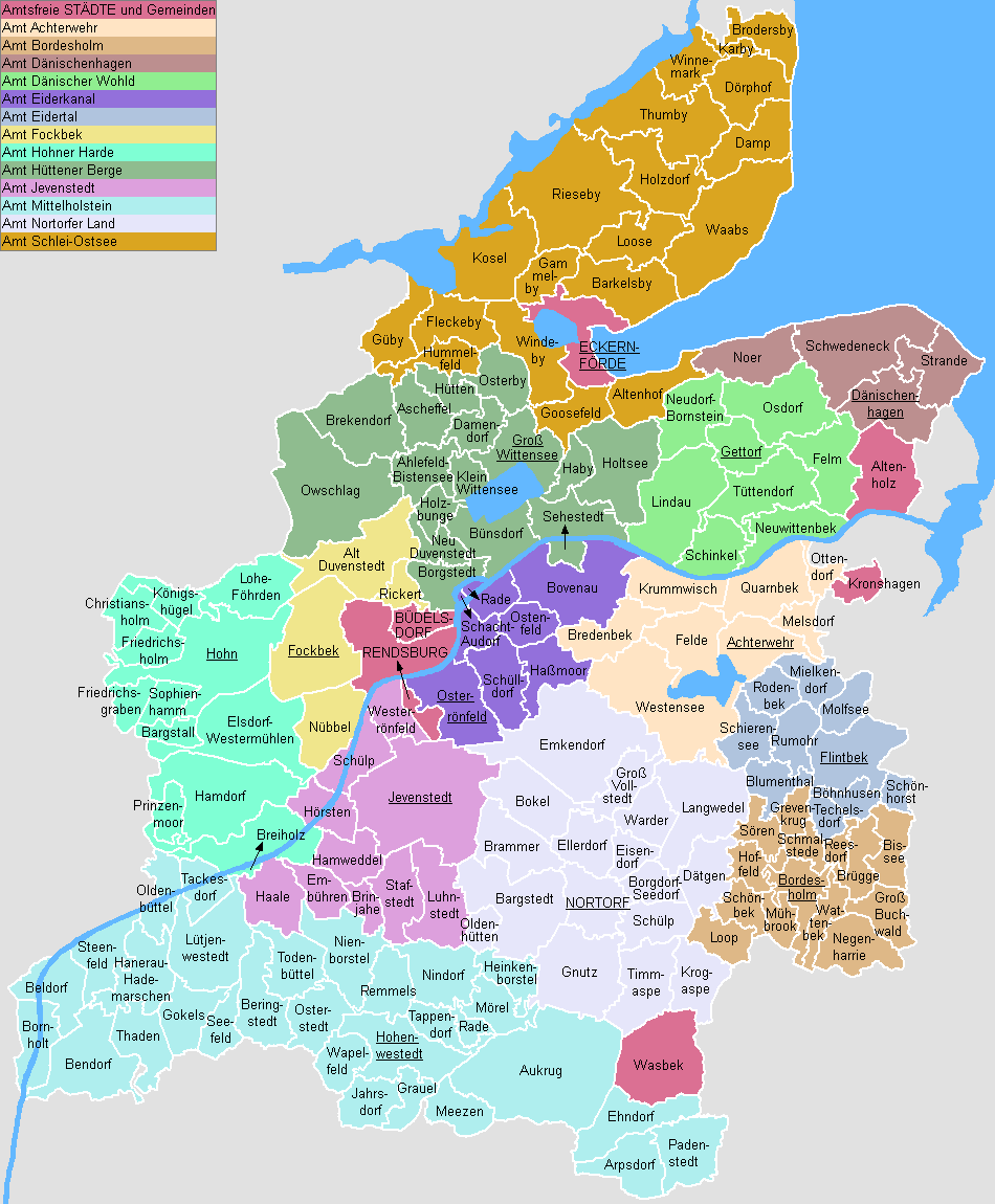
English: This map shows the Ämter (counties) and Gemeinden (municipalities) in the Kreis (district) Rendsburg-Eckernförde in Schleswig-Holstein, Germany.
Deutsch: Diese Karte zeigt die Ämter und Gemeinden im Kreis Rendsburg-Eckernförde, Schleswig-Holstein, Deutschland. |
| Date |
|
| Source | Own work |
| Author | ClausG |
| Permission (Reusing this file) |
GFDL |
Licensing
I, the copyright holder of this work, hereby publish it under the following licenses:

|
Permission is granted to copy, distribute and/or modify this document under the terms of the GNU Free Documentation License, Version 1.2 or any later version published by the Free Software Foundation; with no Invariant Sections, no Front-Cover Texts, and no Back-Cover Texts. A copy of the license is included in the section entitled GNU Free Documentation License. |
| This file is licensed under the Creative Commons Attribution-Share Alike 3.0 Unported license. | ||
| ||
| This licensing tag was added to this file as part of the GFDL licensing update. |
You may select the license of your choice.
File history
Click on a date/time to view the file as it appeared at that time.
| Date/Time | Thumbnail | Dimensions | User | Comment | |
|---|---|---|---|---|---|
| current | 17:08, 1 June 2023 | | 950 × 1,150 (56 KB) | ClausG | Amt Eidertal - Fusion der Ämter Flintbek und Molfsee |
| 12:56, 31 December 2011 |  | 950 × 1,150 (52 KB) | ClausG | Amt Mittelholstein | |
| 17:31, 18 September 2008 |  | 950 × 1,150 (53 KB) | ClausG | Wasbek amtsfrei | |
| 11:16, 1 March 2008 |  | 950 × 1,150 (56 KB) | ClausG | colors corrected | |
| 11:08, 1 March 2008 |  | 950 × 1,150 (55 KB) | ClausG | Fusion Ahlefeld-Bistensee | |
| 13:38, 31 December 2007 |  | 950 × 1,150 (56 KB) | ClausG | Small correction | |
| 13:35, 31 December 2007 |  | 950 × 1,150 (56 KB) | ClausG | Changes for 2008/01/01 | |
| 16:42, 30 June 2007 |  | 950 × 1,150 (56 KB) | ClausG | Beitritt von Bordesholm zum Amt Bordesholm-Land | |
| 15:25, 31 December 2006 |  | 950 × 1,150 (56 KB) | ClausG | ||
| 15:11, 9 August 2006 |  | 950 × 1,150 (55 KB) | ClausG | {{Information |Description={{en|This map shows the Ämter (counties) and Gemeinden (municipalities) in the Kreis (district) Rendsburg-Eckernförde in Schleswig-Holstein, Germany.}} {{de|Diese Karte zeigt die Ämter und Gemeinden im Kreis Rendsburg-Eckernf |
File usage
The following page uses this file:
Global file usage
The following other wikis use this file:
- Usage on da.wikipedia.org
- Usage on de.wikipedia.org
- Usage on en.wikipedia.org
- Usage on es.wikipedia.org
- Usage on fa.wikipedia.org
- Usage on frr.wikipedia.org
- Usage on fr.wikipedia.org
- Usage on fy.wikipedia.org
- Usage on it.wikipedia.org
- Usage on ms.wikipedia.org
- Usage on nl.wikipedia.org
- Usage on no.wikipedia.org
- Usage on pt.wikipedia.org
- Usage on sco.wikipedia.org
- Usage on sv.wikipedia.org
- Usage on tr.wikipedia.org
- Usage on uk.wikipedia.org
- Usage on vi.wikipedia.org