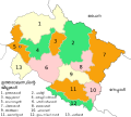
File:UttarakhandDistricts numbered.svg

Size of this PNG preview of this SVG file: 666 × 599 pixels. Other resolutions: 267 × 240 pixels | 533 × 480 pixels | 853 × 768 pixels | 1,138 × 1,024 pixels | 2,276 × 2,048 pixels | 1,250 × 1,125 pixels.
Original file (SVG file, nominally 1,250 × 1,125 pixels, file size: 145 KB)
File history
Click on a date/time to view the file as it appeared at that time.
| Date/Time | Thumbnail | Dimensions | User | Comment | |
|---|---|---|---|---|---|
| current | 13:53, 16 January 2009 |  | 1,250 × 1,125 (145 KB) | GDibyendu | {{Information |Description=District borders with color d0c0a0 as prescribed in WP India cartography dept in en wikipedia |Source=based on previous version only |Date=2009-01-16 |Author=GDibyendu |Permission= |other_versions= }} |
| 18:53, 15 January 2009 |  | 1,250 × 1,125 (145 KB) | GDibyendu | {{Information |Description={{en|1=Based on File:Uttarakhand_locator_map.svg}} |Source=Own work by uploader |Author=GDibyendu |Date=2009-01-16 |Permission= |other_versions= }} <!--{{ImageUpload|full}}--> |
File usage
The following page uses this file:
Global file usage
The following other wikis use this file:
- Usage on en.wikipedia.org
- Usage on eu.wikipedia.org
- Usage on fr.wikipedia.org
- Usage on gu.wikipedia.org
- Usage on hi.wikipedia.org
- Usage on hr.wikipedia.org
- Usage on id.wikipedia.org
- Usage on ml.wikipedia.org
- Usage on mr.wikipedia.org
- Usage on ne.wikipedia.org
- Usage on new.wikipedia.org
- Usage on pl.wikipedia.org
- Usage on ru.wikipedia.org
- Usage on sat.wikipedia.org
- Usage on sa.wikipedia.org
- Usage on ta.wikipedia.org
- Usage on te.wikipedia.org
- Usage on uk.wikipedia.org
- Usage on ur.wikipedia.org
- Usage on zh.wikipedia.org


