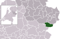
Haaksbergen
village and municipality in the Netherlands
Haaksbergen is a municipality and town in the province of Overijssel, the Netherlands. About 24,000 people were living there in 2021.
Haaksbergen
Hoksebarge | |
|---|---|
Municipality, town | |
 | |
 Location | |
 Map | |
| Coordinates: 52°9′N 6°44′E / 52.150°N 6.733°E | |
| Country | Netherlands |
| Province | Overijssel |
| Region | Twente |
| Area | |
| • Total | 105.50 km2 (40.73 sq mi) |
| • Land | 104.82 km2 (40.47 sq mi) |
| • Water | 0.68 km2 (0.26 sq mi) |
| Elevation | 27 m (89 ft) |
| Population (2019) | |
| • Total | 24,277 |
| • Density | 232/km2 (600/sq mi) |
| Website | www |
Haaksbergen lies in Twente region and borders both Achterhoek region and Germany.
References
change- Plaatsengids.nl Archived 2023-07-07 at the Wayback Machine

