Latgale
Latgale is the historical land of Latvia.
-
 Latgale location
 -
 Coat of arms of Latgale
 -
 Official flag of Latgale


This is a region in the east. It is located to the north of the Daugava River.
The territory of Latgale appears in the 12th and 13th centuries. After 1561, the Polish–Lithuanian Commonwealth ruled. And then the Russian Empire (1772-1918).
The name of the area was "Inflanty". The name "Latgale" was invented by the Latgalian writer Francis Kemps (1876–1953) in 1900. It was originated from the ancient term "Lotigolu".
Latgale is 22% of Latvia.
The highest point is 289 meters (Great Linden Hill).
Latgale is called the land of blue lakes. There are more than 2000 lakes in Latgale.
Latgale has very beautiful nature. Winters are always harsh. A lot of snow.
-
 Winter in Latgale

Main cities are Daugavpils, Rēzekne, Jēkabpils.
-
 Daugavpils
 -
 Rēzekne
 -
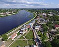 Jēkabpils


.jpg)
Culture
changeHeritage:
- monuments
- churches
- buildings (Kraslava Castle, Luznava Manor, Chervona Castle, Preili Castle and Park, Krustpils Castle)
- landscapes
- ensembles (Russian ensemble "Harmony", Bebrene Manor Ensemble)
Traditions:
- culture
- songs
- dances
- crafts
The cultural heritage list of Latgale contains more than 600 objects.
-
 Daugavpils nature

History
changeUntil the end of the 12th century in Latgale were several state formations of Latgale.
Since 1561, Latgale was a part of the Grand Duchy of Lithuania.
Later it was divided into 4 parts: Daugavpils, Rezekne, Ludza and Vilaka.
In 1772, Latgale was annexed by the Russian Empire.
From 1802 to 1917, Latgale was a part of the Vitebsk Governorate.
In 1919-1920, Latgale was added to the rest of Latvia.