Puhoi, New Zealand
locality in Auckland Region, New Zealand
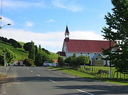
Puhoi is a settlement located 50 kilometers north of Auckland and is on the banks of Puhoi River. The name translates to slow water in Maori. It has a local library and a Roman Catholic church in the settlement.
Puhoi | |
|---|---|
 Puhoi Village | |
 | |
| Coordinates: 36°30′53″S 174°39′44″E / 36.51472°S 174.66222°E | |
| Country | New Zealand |
| Region | Auckland Region |
| Ward | Rodney ward |
| Local board | Rodney Local Board |
| Electorates | |
| Government | |
| • Territorial Authority | Auckland Council |
| Area | |
| • Total | 3.59 km2 (1.39 sq mi) |
| Population (June 2023)[2] | |
| • Total | 420 |
| • Density | 120/km2 (300/sq mi) |
References
change- ↑ Cite error: The named reference
Areawas used but no text was provided for refs named (see the help page). - ↑ "Subnational population estimates (RC, SA2), by age and sex, at 30 June 1996-2023 (2023 boundaries)". Statistics New Zealand. Retrieved 25 October 2023. (regional councils); "Subnational population estimates (TA, SA2), by age and sex, at 30 June 1996-2023 (2023 boundaries)". Statistics New Zealand. Retrieved 25 October 2023. (territorial authorities); "Subnational population estimates (urban rural), by age and sex, at 30 June 1996-2023 (2023 boundaries)". Statistics New Zealand. Retrieved 25 October 2023. (urban areas)