River Trent
The River Trent is one of the major rivers of England. It is the third longest river in the United Kingdom. It starts in Staffordshire. It flows through the centre of England until it joins the River Ouse to form the River Humber (estuary) which empties into the North Sea.
| River Trent | |
|---|---|
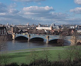
 Trent Bridge, with Nottingham in the background | |
 | |
| Location | |
| Country | United Kingdom |
| Country within the UK | England |
| Counties | Staffordshire, Derbyshire, Leicestershire, Nottinghamshire, Lincolnshire, Yorkshire |
| Cities | Stoke-on-Trent, Nottingham |
| Towns | Stone, Rugeley, Burton upon Trent, Newark-on-Trent, Gainsborough |
| Physical characteristics | |
| Source | |
| - location | Biddulph Moor, Staffordshire, England |
| - coordinates | 53°06′58″N 02°08′25″W / 53.11611°N 2.14028°W |
| - elevation | 275 m (902 ft) |
| Mouth | |
| - location | Trent Falls, Humber Estuary, Lincolnshire, England |
| - coordinates | 53°42′03″N 00°41′28″W / 53.70083°N 0.69111°W |
| - elevation | 0 m (0 ft) |
| Length | 298 km (185 mi) |
| Basin size | 10,435 km2 (4,029 sq mi)[3][c] |
| Discharge | |
| - location | Colwick[1] |
| - average | 84 m3/s (3,000 cu ft/s)[1] |
| - minimum | 15 m3/s (530 cu ft/s)[1][a] |
| - maximum | 1,018 m3/s (36,000 cu ft/s)[2][b] |
| Discharge | |
| - location | North Muskham |
| - average | 88 m3/s (3,100 cu ft/s) |
| Basin features | |
| Tributaries | |
| - left | Blithe, Swarbourn, Dove, Derwent, Erewash, Leen, Greet, Idle, Torne |
| - right | Sow, Tame, Mease, Soar, Devon, Eau |
| Progression : River Trent — Humber — North Sea | |
The name "Trent" comes from a Celtic word possibly meaning "strongly flooding". More specifically, the name may be a contraction of two Celtic words, tros ("over") and hynt ("way").[5]
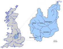
It is unusual amongst English rivers in that it flows north (for the second half of its route), and is also unusual in exhibiting a tidal bore, the "Aegir". The area drained by the river includes most of the northern Midlands.
Navigation
changeThe river is legally navigable for some 117 miles (188 kilometres) below Burton upon Trent. However, for practical purposes, navigation above the southern terminus of the Trent and Mersey Canal (at Shardlow) is conducted on the canal, rather than on the river itself.
Trent Aegir
changeAt certain times of the year, the lower tidal reaches of the Trent experience a tidal bore which can be up to 5 feet (1.5 metres) high.
Notes
changeReferences
change- ↑ 1.0 1.1 1.2 "28009 – Trent at Colwick". The National River Flow Archive. Centre for Ecology & Hydrology. Retrieved 24 March 2013.
- ↑ "Hi Flows UK". Environment Agency. Retrieved 4 March 2013.
- ↑ Trent River Authority. Official Handbook of the Trent River Authority. Cheltenham and London:Ed. J. Burrow and Co. Ltd, 1972.
- ↑ "Midlands Catchment Flood Management Plans". Environment Agency. Retrieved 11 April 2013.
- ↑ "University of Wales Online Dictionary". Archived from the original on 2015-06-08. Retrieved 2009-05-18.
Other websites
changeMedia related to River Trent at Wikimedia Commons