Roseville, New South Wales
suburb on the Upper North Shore of Sydney in the state of New South Wales
Roseville is a suburb in northern Sydney. It has passenger trains and buses to and from Hornsby and Sydney CBD.[2]
| Roseville Sydney, New South Wales | |||||||||||||||
|---|---|---|---|---|---|---|---|---|---|---|---|---|---|---|---|
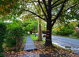
 Waimea Road | |||||||||||||||
| Population | 10,340 (SAL 2021)[1] | ||||||||||||||
| Established | 1814 | ||||||||||||||
| Postcode(s) | 2069 | ||||||||||||||
| Elevation | 109 m (358 ft) | ||||||||||||||
| Area | 3.4 km2 (1.3 sq mi) | ||||||||||||||
| Location | 12 km (7 mi) north-west of Sydney CBD | ||||||||||||||
| LGA(s) |
| ||||||||||||||
| State electorate(s) | Davidson, Willoughby | ||||||||||||||
| Federal division(s) | Bradfield, Warringah | ||||||||||||||
| |||||||||||||||
References
change- ↑ Australian Bureau of Statistics (28 June 2022). "Roseville (suburb and locality)". Australian Census 2021 QuickStats. Retrieved 28 June 2022.
- ↑ Transport for NSW, Customer Experience Division. "Roseville Station". transportnsw.info. Retrieved 2024-12-12.
