Steinschartenkopf
mountain of the Allgäu Alps in Tyrol, Austria
The Steinschartenkopf is a 2,615 metres (8,579 ft) high mountain in the Allgäu Alps.[1] It is north of the Hohes Licht, in Tyrol, Austria. It is the sixth tallest mountain in the Allgäu Alps.[1] The popular Heilbronn Way (Heilbronner Weg) runs over the summit.[2] It is the highest point on the Heilbronn Way.
| Steinschartenkopf | |
|---|---|
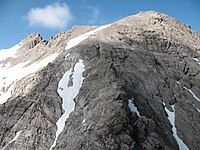
 The Steinschartenkopf from the south between the Kleiner Steinscharte and Socktalscharte notches | |
| Highest point | |
| Elevation | 2615 |
| Prominence | 74 m ↓ Kleine Steinscharte |
| Isolation | 0.4 km → Hohes Licht |
| Coordinates | 47°17′06″N 10°16′51″E / 47.285°N 10.28083°E |
| Geography | |
| Parent range | Central Ridge, Allgäu Alps |
| Climbing | |
| Normal route | along the Heilbronn Way |

Gallery
change-
 Steinschartenkopf from the Bockkarkopf
 -
 The Heilbronn Way, over the summit of the Steinschartenkopf


Additional reading
change- Dieter Seibert: Allgäuer Alpen Alpin, Alpine Club Guide. Munich, Bergverlag Rudolf Rother, 2004. ISBN 3-7633-1126-2
- Alpine Club map 1:25,000 series, Sheet 2/1, Allgäuer- Lechtaler Alpen, West
References
change- ↑ 1.0 1.1 "Steinschartenkopf". Peakware, World Mountain Encyclopedia. Interactive Outdoors, Inc. Retrieved January 15, 2017.[permanent dead link]
- ↑ "Heilbronner Weg". lechtal-info.com. Archived from the original on August 10, 2016. Retrieved January 14, 2017.