Ōhura
locality in New Zealand
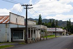
Ōhura is a small town in the Ruapehu District, west of the North Island. It is situated west of Taumarunui in the King Country. It has a primary school and was once the centre of coal mining until 1965, railway network and has hit hard times with the population steadily decreasing since the 1990s. It has Ohura River running the village.
Ōhura | |
|---|---|
Town | |
 Part of the Ōhura township | |
 | |
| Coordinates: 38°50′35″S 174°58′55″E / 38.84306°S 174.98194°E | |
| Country | New Zealand |
| Region | Manawatū-Whanganui |
| District | Ruapehu District |
| Ward |
|
| Community | Taumarunui-Ōhura Community |
| Electorates | |
| Government | |
| • Territorial Authority | Ruapehu District Council |
| • Regional council | Horizons Regional Council |
| Area | |
| • Total | 3.25 km2 (1.25 sq mi) |
| Population (2018 census)[2] | |
| • Total | 126 |
| • Density | 39/km2 (100/sq mi) |
References
change- ↑ "ArcGIS Web Application". statsnz.maps.arcgis.com. Retrieved 30 March 2023.
- ↑ "Statistical area 1 dataset for 2018 Census". Statistics New Zealand. March 2020. 7017557.