Regions of New Zealand
local government areas of New Zealand
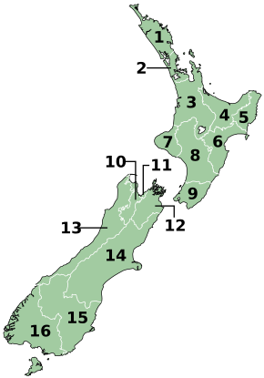
New Zealand is divided into 16 regions (Māori: ngā rohe) for local government purposes.
| Regions | |
|---|---|
 | |
| Category | Unitary state |
| Location | |
| Number | 16 |
| Populations | 32,900 (West Coast) – 1,739,300 (Auckland) |
| Areas | 450 km2 (172 sq mi) (Nelson) – 45,350 km2 (17,508 sq mi) (Canterbury) |
| Government | Local government |
| Subdivisions | Territorial authority |
List of regions
change| Name (name in Māori if different) |
Regional council | Seats | Council seat | Island | Land area (km2)[1] |
Population[2] | Density
(pop./km2) |
ISO 3166-2 Code | |
|---|---|---|---|---|---|---|---|---|---|
| 1 | Northland Te Tai Tokerau |
Northland Regional Council | 9 | Whangārei | North | 12,504 | 203,900 | 16.31 | NZ-NTL
|
| 2 | Auckland(1) Tāmaki-makau-rau |
Auckland Council | 21 | Auckland | North | 4,941 | 1,739,300 | 352.01 | NZ-AUK
|
| 3 | Waikato | Waikato Regional Council | 14 | Hamilton | North | 23,900 | 522,600 | 21.87 | NZ-WKO
|
| 4 | Bay of Plenty Te Moana-a-Toi |
Bay of Plenty Regional Council | 14 | Whakatāne | North | 12,072 | 354,100 | 29.33 | NZ-BOP
|
| 5 | Gisborne(1)(2) Te Tairāwhiti |
Gisborne District Council | 14 | Gisborne | North | 8,385 | 52,600 | 6.27 | NZ-GIS
|
| 6 | Hawke's Bay Te Matau-a-Māui |
Hawke's Bay Regional Council | 9 | Napier | North | 14,138 | 184,800 | 13.07 | NZ-HKB
|
| 7 | Taranaki | Taranaki Regional Council | 11 | Stratford | North | 7,254 | 128,700 | 17.74 | NZ-TKI
|
| 8 | Manawatū-Whanganui | Horizons Regional Council | 12 | Palmerston North | North | 22,221 | 260,900 | 11.74 | NZ-MWT
|
| 9 | Wellington Te Whanga-nui-a-Tara |
Greater Wellington Regional Council | 13 | Wellington | North | 8,049 | 550,500 | 68.39 | NZ-WGN
|
| 10 | Tasman(1) Te Tai-o-Aorere |
Tasman District Council | 13 | Richmond | South | 9,616 | 59,400 | 6.18 | NZ-TAS
|
| 11 | Nelson(1) Whakatū |
Nelson City Council | 13 | Nelson | South | 422 | 55,600 | 131.75 | NZ-NSN
|
| 12 | Marlborough(1) Te Tauihu-o-te-waka |
Marlborough District Council | 14 | Blenheim | South | 10,458 | 52,200 | 4.97 | NZ-MBH
|
| 13 | West Coast Te Tai Poutini |
West Coast Regional Council | 7 | Greymouth | South | 23,245 | 32,900 | 1.42 | NZ-WTC
|
| 14 | Canterbury Waitaha |
Environment Canterbury | 14 | Christchurch | South | 44,504 | 666,300 | 14.97 | NZ-CAN
|
| 15 | Otago Ōtākou |
Otago Regional Council | 12 | Dunedin | South | 31,186 | 254,600 | 8.16 | NZ-OTA
|
| 16 | Southland Murihiku |
Southland Regional Council | 12 | Invercargill | South | 31,196 | 103,900 | 3.33 | NZ-STL
|
Notes:
(1) These regions have unitary authorities.
(2) The Gisborne Region is still widely but unofficially known by its former name East Cape or as the East Coast.[3]
References
change- ↑ "Regional Council 2020 Clipped (generalised)". Stats NZ. 30 January 2020. Retrieved 21 September 2020.
- ↑ "Subnational population estimates (RC, SA2), by age and sex, at 30 June 1996-2023 (2023 boundaries)". Statistics New Zealand. Retrieved 25 October 2023. (regional councils); "Subnational population estimates (TA, SA2), by age and sex, at 30 June 1996-2023 (2023 boundaries)". Statistics New Zealand. Retrieved 25 October 2023. (territorial authorities); "Subnational population estimates (urban rural), by age and sex, at 30 June 1996-2023 (2023 boundaries)". Statistics New Zealand. Retrieved 25 October 2023. (urban areas)
- ↑ Soutar, Monty (1 March 2015). "East Coast places - Gisborne". Te Ara: The Encyclopedia of New Zealand. Retrieved 4 April 2020.