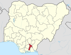
Abia State
state in Nigeria
Abia State (Igbo: Ȯha Abia) is one of the 36 states of Nigeria situated in the South Eastern part of Nigeria. The capital is Umuahia.[3]
Abia State
Ọ̀hà nke Chineke (Igbo) | |
|---|---|
 Location of Abia State in Nigeria | |
| Coordinates: 5°25′N 7°30′E / 5.417°N 7.500°E | |
| Country | |
| Geopolitical Zone | South East |
| Date created | 27 August 1991 |
| Capital | Umuahia |
| Number of LGAs | 17[1] |
| Government | |
| • Governor | Alex Otti (Labour Party) |
| • Deputy Governor | Ikechukwu Emetu (Labour Party) |
| • Senators | |
| • Representatives | List |
| • Legislature | Abia State House of Assembly |
| Area | |
| • Total | 6,320 km2 (2,440 sq mi) |
| • Rank | 32 |
| Population (2006 census) | |
| • Total | 4,112,230 |
| GDP | |
| • Year | 2021 |
| • Total | $22.83 billion |
| • Per capita | $5,351 |
| Time zone | UTC+01 (WAT) |
| ISO 3166 code | NG-AB |
| HDI (2021) | 0.644[2] medium · 8th of 37 |
| Website | Official website |
Local Government Areas
changeAbia State consists of 17 local governments namely : Aba North, Aba South, Isiala Ngwa North, Isiala Ngwa South, Ukwa West, Ukwa East, Obingwa, Ikwuano, Bende, Arochukwu, Ohafia, Isuikwuato, Umuahia North, Umuahia South, Ugwunagbo, Osisioma and Nnochi[4]
References
change- ↑ "Abia State – Nigerian Investment Promotion Commission". nicp.gov.ng.
- ↑ "Sub-national HDI - Area Database - Global Data Lab". hdi.globaldatalab.org. Retrieved 2018-09-13.
- ↑ "History of Abia State Nigeria". Archived from the original on 2021-09-18. Retrieved 2021-09-18.
- ↑ "Abia State". Nigerian Investment Promotion Commission. 2018-12-30. Retrieved 2023-12-17.
