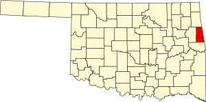
Adair County, Oklahoma
county in Oklahoma, United States
Adair County is a county in the U.S. state of Oklahoma. As of 2020, 19,495 people lived there.[1] Its county seat is Stilwell.
Adair County | |
|---|---|
 Adair County Courthouse | |
 Location within the U.S. state of Oklahoma | |
 Oklahoma's location within the U.S. | |
| Coordinates: 35°53′N 94°40′W / 35.88°N 94.66°W | |
| Country | |
| State | |
| Founded | July 16, 1907 |
| Named for | The Adair family of the Cherokee tribe. |
| Seat | Stilwell |
| Largest city | Stilwell |
| Area | |
| • Total | 577 sq mi (1,490 km2) |
| • Land | 573 sq mi (1,480 km2) |
| • Water | 3.6 sq mi (9 km2) 0.6% |
| Population (2020) | |
| • Total | 19,495 |
| • Density | 34/sq mi (13/km2) |
| Time zone | UTC−6 (Central) |
| • Summer (DST) | UTC−5 (CDT) |
| Congressional district | 2nd |
History
changeThe county was created in 1907.
Geography
changeThe county has a total area of 577 square miles.
Places
changeCities
change- Stilwell (county seat)
Towns
change- Watts
- Westville
Other
change- Ballard
- Baron
- Bell
- Bunch
- Cherry Tree
- Chewey
- Christie
- Elm Grove
- Elohim City
- Fairfield
- Greasy
- Lyons Switch
- Marietta
- Mulberry
- Old Green
- Peavine
- Piney
- Proctor
- Rocky Mountain
- Salem
- Titanic
- Watts Community
- Wauhillau
- West Peavine
- Zion
References
change- ↑ "QuickFacts: Adair County, Oklahoma". United States Census Bureau. Retrieved January 18, 2024.