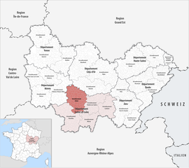
Arrondissement of Autun
The arrondissement of Autun is an arrondissement of France. It is part of the Saône-et-Loire département in the Bourgogne-Franche-Comté region. Its capital is the city of Autun.
Autun | |
|---|---|
 Location within the region Bourgogne-Franche-Comté | |
| Country | France |
| Region | Bourgogne-Franche-Comté |
| Department | Saône-et-Loire |
| No. of communes | 89 |
| Subprefecture | Autun |
| Area | 1,994.3 km2 (770.0 sq mi) |
| Population (Jan. 2019)[1] | 127,616 |
| INSEE code | 711 |
History
changeWhen the Saône-et-Loire department was created on 17 February 1800, the arrondissement of Autun was part of that original department.[2]
Geography
changeThe arrondissement of Autun is bordered to the north by the Côte-d'Or department, to the east by the arrondissement of Chalon-sur-Saône, to the south by the arrondissement of Charolles and to the west by the Nièvre department.
It is the northernmost of the arrondissements of the department, with an area of 1,900.3 km2 (734 sq mi),[3] the second largest in area of the department. It has 86,693 inhabitants and a population density of 45.6 inhabitants/km².[4]
Composition
changeCantons
changeAfter the reorganisation of the cantons in France,[5] cantons are not subdivisions of the arrondissements so they could have communes that belong to different arrondissements.
The cantons of the arrondissement of Autun are:
- Autun-1
- Autun-2
- Blanzy (partly)
- Chagny (partly)
- Le Creusot-1
- Le Creusot-2
- Gueugnon (partly)
- Montceau-les-Mines (partly)
Communes
changeThe arrondissement of Autun has 83 communes; they are (with their INSEE codes):[6]
- Anost (71009)
- Antully (71010)
- Autun (71014)
- Auxy (71015)
- Barnay (71020)
- Blanzy (71040)
- Brion (71062)
- Broye (71063)
- Change (71085)
- Charbonnat (71098)
- Charmoy (71103)
- Cheilly-lès-Maranges (71122)
- Chissey-en-Morvan (71129)
- Collonge-la-Madeleine (71140)
- Cordesse (71144)
- Couches (71149)
- Cressy-sur-Somme (71152)
- Créot (71151)
- Curgy (71162)
- Cussy-en-Morvan (71165)
- Cuzy (71166)
- Dettey (71172)
- Dezize-lès-Maranges (71174)
- Dracy-Saint-Loup (71184)
- Dracy-lès-Couches (71183)
- Essertenne (71191)
- Grury (71227)
- Igornay (71237)
- Issy-l'Évêque (71239)
- La Boulaye (71046)
- La Celle-en-Morvan (71509)
- La Chapelle-sous-Uchon (71096)
- La Comelle (71142)
- La Grande-Verrière (71223)
- La Petite-Verrière (71349)
- La Tagnière (71531)
- Laizy (71251)
- Le Breuil (71059)
- Le Creusot (71153)
- Les Bizots (71038)
- Lucenay-l'Évêque (71266)
- Marly-sous-Issy (71280)
- Marmagne (71282)
- Mesvres (71297)
- Montcenis (71309)
- Monthelon (71313)
- Montmort (71317)
- Morlet (71322)
- Paris-l'Hôpital (71343)
- Perreuil (71347)
- Reclesne (71368)
- Roussillon-en-Morvan (71376)
- Saint-Berain-sous-Sanvignes (71390)
- Saint-Didier-sur-Arroux (71407)
- Saint-Eugène (71411)
- Saint-Firmin (71413)
- Saint-Forgeot (71414)
- Saint-Gervais-sur-Couches (71424)
- Saint-Jean-de-Trézy (71431)
- Saint-Léger-du-Bois (71438)
- Saint-Léger-sous-Beuvray (71440)
- Saint-Martin-de-Commune (71450)
- Saint-Maurice-lès-Couches (71464)
- Saint-Nizier-sur-Arroux (71466)
- Saint-Pierre-de-Varennes (71468)
- Saint-Prix (71472)
- Saint-Sernin-du-Bois (71479)
- Saint-Sernin-du-Plain (71480)
- Saint-Symphorien-de-Marmagne (71482)
- Saint-Émiland (71409)
- Sainte-Radegonde (71474)
- Saisy (71493)
- Sampigny-lès-Maranges (71496)
- Sommant (71527)
- Sully (71530)
- Tavernay (71535)
- Thil-sur-Arroux (71537)
- Tintry (71539)
- Torcy (71540)
- Uchon (71551)
- Épertully (71188)
- Épinac (71190)
- Étang-sur-Arroux (71192)
The communes with more inhabitants in the arrondissement are:
| INSEE code |
Commune | Population[4] (2014) |
Canton | Intercommunality |
|---|---|---|---|---|
| 71153 | Le Creusot | 21,991 | Le Creusot-1 and Le Creusot-2 | Communauté urbaine Le Creusot Montceau-les-Mines |
| 71014 | Autun | 13,955 | Autun-1 and Autun-2 | Le Grand Autunois Morvan |
| 71040 | Blanzy | 6,457 | Blanzy | Communauté urbaine Le Creusot Montceau-les-Mines |
| 71059 | Le Breuil | 3,560 | Le Creusot-2 | Communauté urbaine Le Creusot Montceau-les-Mines |
| 71540 | Torcy | 3,062 | Le Creusot-1 | Communauté urbaine Le Creusot Montceau-les-Mines |
| 71190 | Épinac | 2,265 | Autun-1 | Le Grand Autunois Morvan |
| 71309 | Montcenis | 2,188 | Le Creusot-1 | Communauté urbaine Le Creusot Montceau-les-Mines |
| 71192 | Étang-sur-Arroux | 1,922 | Autun-2 | Le Grand Autunois Morvan |
| 71149 | Couches | 1,435 | Chagny | Le Grand Autunois Morvan |
| 71282 | Marmagne | 1,238 | Autun-2 | Communauté urbaine Le Creusot Montceau-les-Mines |
Related pages
changeReferences
change- ↑ "Téléchargement du fichier d'ensemble des populations légales en 2019". The National Institute of Statistics and Economic Studies. 28 December 2020.
- ↑ "Historique de Saône-et-Loire". Le SPLAF (in French). Retrieved 10 November 2014.
- ↑ "Arrondissement d'Autun (711)". Comparateur de territoire (in French). Institut national de la statistique et des études économiques - INSEE. Retrieved 21 June 2017.
- ↑ 4.0 4.1 "Régions, départements, arrondissements, cantons et communes" (PDF). Populations légales 2014 (in French). Institut national de la statistique et des études économiques - INSEE. Retrieved 21 June 2017.
- ↑ "Décret n° 2014-182 du 18 février 2014 portant délimitation des cantons dans le département de Saône-et-Loire" (in French). Legifrance.gouv.fr. 13 February 2014. Retrieved 21 June 2017.
- ↑ "Arrondissement d'Autun (711)". Géographie administrative et d'étude (in French). Institut national de la statistique et des études économiques - INSEE. Retrieved 21 June 2017.