Budaun district
district of Uttar Pradesh, India
Budaun district is one of the districts of Uttar Pradesh state of India. Budaun city is the headquarter. It is the part of Bareilly division.[1]
Budaun district | |
|---|---|
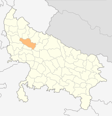
 Location of Budaun district in Uttar Pradesh | |
| Country | India |
| State | Uttar Pradesh |
| Division | Bareilly |
| Headquarters | Budaun |
| Tehsils | 6 |
| Government | |
| • Lok Sabha constituencies | Badaun, Aonla (partly) |
| • Vidhan Sabha constituencies | 6 |
| Area | |
| • Total | 4,234 km2 (1,635 sq mi) |
| Population (2011) | |
| • Total | 3,681,896 |
| • Density | 870/km2 (2,300/sq mi) |
| • Urban | 826,000 |
| Demographics | |
| • Literacy | 52.91 per cent |
| Time zone | UTC+05:30 (IST) |
| Major highways | SH33, SH43, SH51, SH18, NH 93 |
| Website | https://budaun.nic.in/ |

At a Glance
change- Area: 4234.21 Sq. Km.
- Population: 31,29,000
- Male: 16,71,000
- Female: 14,58,000
- Language: Hindi
- Villages: 1698
Tehsils
changeThere are 5 tehsils in Budaun district.[2]
- Budaun
- Bisauli
- Bilsi
- Dataganj
- Sahaswan