Cairngorms
The Cairngorms (Scottish Gaelic: Am Monadh Ruadh) is a group of mountains in the eastern part of Highlands of Scotland. It is usually linked with the mountain of the Cairn Gorm. The Cairngorms became part of Scotland's second national park (the Cairngorms National Park) on 1 September 2003.[2] It was part of the tentative list of UNESCO World Heritage Sites.[3][4]
| Cairngorms | |
|---|---|
IUCN category IV (habitat/species management area) | |
 Cairn Gorm view over Coire an t-Sneachda, a glacial cirque | |
| Location | Highland, Aberdeenshire and Moray, Scotland |
| Nearest city | Inverness, Aberdeen |
| Coordinates | 57°05′N 3°40′W / 57.083°N 3.667°W |
| Area | 292 km2 (113 sq mi)[1] |
| Established | 1987[1] |
| Governing body | Scottish Natural Heritage |
The Cairgorms, Angus Glens, Monadhliath, and lower areas of Strathspey, make up the Cairngorms National Park.[5]
Geography
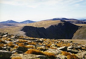
changeThe Cairngorms is made of high plateau that is about 1000–1200 m above sea level. They have domed summits that [6] that are around 1300 m. high. Many of the summits have tors. These are basically free-standing rock formations that stand on top of the rocky landscape.[7]
The edges of the plateau that have narrow cliffs of granite. It makes it ideal for skiing, rock climbing and ice climbing.
Animals
changeThe area is home to birds such as ptarmigan, dotterel, snow bunting, curlew and red grouse, as well as mammals such as mountain hare.[8]
The plateau is also home to Britain's only herd of reindeer.[9] Next to the central massif are the remainders of the Caledonian forest.[10] These forests support many species that are not found anywhere elsewhere in the United Kingdom. These include red squirrels, pine marten, wood ants, Scottish crossbill, capercaillie and crested tit.[11]
Activities
changeThere are no glaciers in the area. However, snow can fall at any month of the year. In fact, some snow may be found all summer. It is the most ideal place for ice climbing in Britain.[12][13]
The mountains are also popular for hill-walking, ski touring and climbing. There are also three alpine ski centres within the area: Cairn Gorm, The Lecht and Glenshee.
The range lies in the Scottish council areas of Aberdeenshire, Moray and Highland,[14] and within the counties of Aberdeenshire, Invernessshire and Banffshire.
Name
changeThe original Gaelic name for the area is Am Monadh Ruadh, (the red hills). It is different from Am Monadh Liath (the grey hills) which lie to the west of the River Spey:
If you look from Aviemore on a clear evening, the granite screes of Lairig Ghru and Braeriach do glow a warm red in the sun. The name Am Monadh Ruadh still lives among the oldest folk of Strath Spey, but long ago, outsiders had replaced it with 'the Cairngorms', on maps and in guide books.
— Watson [15]
The English language name for the area is Cairngorms. It came from Cairn Gorm. It is the prominent in the view of the mountains from Speyside. The earliest time when the name appeared in the history is from a Colonel T. Thornton who visited the area in about 1786:[15][16]
The use of the term "Cairngorms" as applied to the group must have become well established early in the nineteenth century, for we find it in Col Thornton's Sporting Tour (1804), where there is a reference to "Aurora peeping over the immense Cairngorms."
— Alexander [16] (p21)
Cairn Gorm means Blue Cairn. Although the Gaelic gorm can also be used as an adjective and verb. It means green or greening, and is often seen in connection with growing grass.[17]
Gallery
change-
Cairn Lochan (1215 m).
-
View north-west from the summit of Beinn Bhreac (931 m).
Related pages
changeReferences
change- ↑ 1.0 1.1 "Details for Cairngorms". SNH. 2018-03-05. Retrieved 2018-03-28.
- ↑ "History Leading to the Cairngorms National Park". Cairngorms National Park Authority. Archived from the original on 2018-01-15. Retrieved 2018-01-15.
- ↑ Centre, UNESCO World Heritage. "UNESCO World Heritage Centre - Tentative Lists". UNESCO World Heritage Centre. Retrieved 2020-08-17.
- ↑ "Cairngorms park boundary extended". BBC News. 2010-10-04. Retrieved 2020-08-17.
- ↑ "Cairngorms Landscapes". Cairngorms National Park. Retrieved 2018-02-20.
- ↑ Allen & Davidson (2012), Prologue: The Mountains, p. 1/14.
- ↑ "Landscape Character Assessment - The Cairngorms Massif" (PDF). Cairngorms National Park Authority. Archived from the original (PDF) on 2018-02-20. Retrieved 2018-02-20.
- ↑ "What to look for in mountains and moorlands". Cairgorms Nature (Cairngorms National Park Authority ). Retrieved 2018-02-20.
- ↑ "History". The Cairngorm Reindeer Herd. 2018. Retrieved 2018-02-19.
- ↑ "Cairngorms National Park". walkhighlands.co.uk. Retrieved 2018-02-20.
- ↑ "What is left of the Old Caledonian Forest - and can it be saved?". The Scotsman. 2016-02-11. Archived from the original on 2018-02-21. Retrieved 2018-02-20.
- ↑ Watson (1992), p. 16.
- ↑ English, Charlie (7 February 2009). "Doctor Watson's feeling for snow". Guardian. Archived from the original on 20 February 2016. Retrieved 20 February 2016.
- ↑ Ordnance Survey Landranger 1:50000, Sheet 36
- ↑ 15.0 15.1 Watson, Adam (1975). The Cairngorms. Edinburgh: The Scottish Mountaineering Trust.
- ↑ 16.0 16.1 Alexander, Henry (1928). The Cairngorms. Edinburgh: The Scottish Mountaineering Club.
- ↑ Dwelly, William Robertson, Michael Bauer, Edward. "Dwelly-d - Dwelly's Classic Scottish Gaelic Dictionary".
{{cite web}}: CS1 maint: multiple names: authors list (link)
Notes
change- Allen, John; Davidson, Robert (2012). Cairngorm John: A Life in Mountain Rescue (eBook). Dingwall: Sandstone Press. ISBN 978-1-908737-48-9. John Allen joined the Cairngorm Mountain Rescue Team after the time of the disaster and went on to become its leader.
- Baker, Patrick (2014). "The Lost Shelter". The Cairngorms: A Secret History. Birlinn. ISBN 9780857908094.
- Watson, Adam (1992). The Cairngorms, Lochnagar and the Mounth (6th ed.). Scottish Mountaineering Trust. ISBN 0-907521-39-8. Adam Watson is an academic and hill walker with very great experience of the Cairngorms.
