Cayo District
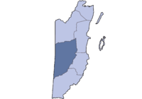
Cayo District is a district in the west of the nation of Belize. The District capital is the town of San Ignacio.
Cayo District | |
|---|---|
 Location of the district in Belize | |
| Coordinates: 16°50′N 88°55′W / 16.833°N 88.917°W | |
| Country | |
| Capital | San Ignacio |
| Population (2009)[1] | |
| • Total | 80,800 |
| Website | www.gotocayobelize.com |
Geography
changeThe Cayo District is the largest in Belize. It is on the western side of the country which borders Guatemala. The nation's capital, Belmopan, is in the district.
The Cayo District has the Pre-Columbian Maya ruins of Xunantunich, Cahal Pech, Chaa Creek, and Caracol. Major rivers in the district include the Macal River and the Mopan River.
Importance and Location
changeThe Cayo District is mostly an agricultural district. The chief crops are citrus, (oranges, grapefruit, and tangerine), as well as bananas. Recently oil was found in Spanish Lookout and is now in production. In addition to the ruins listed above there are several other important nature reserves including two National Parks, Blue Hole (park) and Guanacaste National Park. Ecotourism is also an important part of the region's economy.
According to the 2000 census, Cayo District had a population of 53,715 people.
References
change- ↑ "Mid‐Year Population by District and Sex, 2009" (PDF). Statistical Institute of Belize.