Coronel Fabriciano
town in Minas Gerais, Brazil
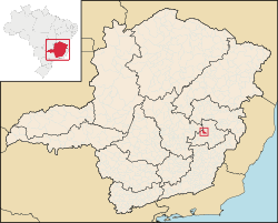
Coronel Fabriciano is a Brazilian city in the Vale do Aço metropolitan area, state of Minas Gerais. It is in the region of Vale do Rio Doce and is 200 km from the state capital. The municipal population was estimated in 2020 by IBGE in 110,290 inhabitants, with an area of 221.252 km².[1]
Coronel Fabriciano | |
|---|---|
Municipality | |
| The Municipality of Coronel Fabriciano | |
 Partial view of Coronel Fabriciano seen from Timóteo | |
| Nickname(s): "Fabri" "Fabriciano" "Terra mãe do Vale do Aço" | |
 | |
| Coordinates: 19°31′08″S 42°37′44″W / 19.51889°S 42.62889°W | |
| Country | |
| Region | Southeast |
| State | |
| Founded | December 27, 1948 |
| Government | |
| • Mayor | Marcos Vinícius da Silva Bizarro (PSDB) |
| Area | |
| • Total | 221.252 km2 (85.426 sq mi) |
| Population (2020) | |
| • Total | 110.290 |
| Time zone | UTC-3 |
| Postal Code | 35170-000 |
| HDI (2010) | 0.755 – high |
| Website | http://www.fabriciano.mg.gov.br/ |
The city was founded in December 27, 1948. The devolviment of the municipality is due to the large companies in the region, such as Aperam South America (old Acesita) and Usiminas, whose industries were in Coronel Fabriciano at they time they were constructed. But in 1964, Fabriciano lost the industrial areas, due to the separation of Timóteo and Ipatinga from this city.[2]
It borders Ipatinga, Timóteo, Ferros, Joanésia, Antônio Dias and Mesquita.
References
change- ↑ Instituto Brasileiro de Geografia e Estatística (IBGE). "Coronel Fabriciano" (in Portuguese). Archived from the original on October 12, 2020. Retrieved February 20, 2019.
- ↑ Revista Caminhos Gerais, number 18, page 7
Other websites
change- Official site of Coronel Fabriciano Archived 2010-01-15 at the Wayback Machine


