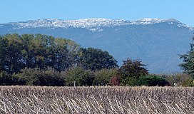
Crêt de la Neige
Crêt de la Neige is a 1,720 m (5,643 ft) high mountain in the commune of Thoiry. It is the highest peak in the Jura Mountains and the department of Ain in France.
| Crêt de la Neige | |
|---|---|
 | |
| Highest point | |
| Elevation | 1,720 m (5,640 ft)[1] |
| Prominence | 1,267 m (4,157 ft) |
| Isolation | 41.3 km (25.7 mi) |
| Coordinates | 46°16′21″N 5°56′37″E / 46.27250°N 5.94361°E |
| Geography | |
Location in the Alps | |
| Location | Ain, Auvergne-Rhône-Alpes, France |
| Parent range | Jura Mountains |
| Geology | |
| Age of rock | Miocene |
| Climbing | |
| Easiest route | Hiking from the Tiocan lookout |
It is in the Jura Mountains Regional Natural Park (French: Parc naturel régional du Haut-Jura).
Geography
changeCrêt de la Neige is between the communes of Lélex (to the northwest) and Thoiry (to the southeast) in the Ain department.
It is found in the Haute Chaîne, the most eastern and highest chain of the French Jura mountains; it is in the Pays de Gex (the Arrondissement of Gex, Ain department), about 17 km (11 mi) to the northwest of the city of Geneva.
The Crêt de la Neige is surrounded by the plain of the Pays de Gex to the east and the Valserine valley (a valley among the Jura mountains formed by the Valserine river) to the west.
From the summit (or near the summit because it is covered with shrubs and trees),[2] it is possible to see Geneva and the Pays de Gex and there is a 360° view over the Lake Geneva, the Valserine valley, La Dôle (a peak of the Jura mountains that is in Switzerland) and the Alps. On a clear day, it is possible to see the Vosges mountains and the Black Forest.
Elevation
changeIn the past, the official elevation given for the Crêt de la Neige was 1,717.6 m (5,635 ft), and so it appears in old maps, only 20 cm (8 in) higher than the near peak of Reculet 1,717.4 m (5,635 ft). But recent studies made by the Institut géographique national (IGN) in Villeurbanne found that the true altitude of the Crêt de la Neige is 1,720 m (5,643 ft) above sea level. In 2024, a team of researchers locates the actual highest peak in a protected area and measures its elevation at 1720.83 m, while they found the geodetic marker at Crêt de la Neige at 1718.06 m elevation.[3]
Getting there
changeThe easiest route to get to the Crêt de la Neige is from the Tiocan lookout point that is beyond Thoiry.[2]
Gallery
change-
Looking towards Geneva from the summit of Cret de la Neige
-
Looking towards Lélex from just below Crêt de la Neige summit (1717.6m)
-
Crêt de la Neige viewed from the summit of Le Reculet
-
Le Reculet from the Crêt de la Neige
References
change- ↑ "Crêt de la Neige, France". Peakbagger.com. Retrieved 10 November 2016.
- ↑ 2.0 2.1 "Crêt de la Neige". SummitPost.org. Retrieved 10 November 2016.
- ↑ Hetényi G., Chagros A.-M., Lemke K., Maharaj A., Baron L. (2024). Détermination du point culminant du massif du Jura. Mémoires de Géologie (Lausanne), n° 51, 6 pp.[1]
Other websites
change- Crêt de la Neige in Camp-to-Camp (in French)
- Crêt de la Neige in GeoFinder.ch (in German)
- Crêt de la Neige at Altituderando.com (in French)
