Dadou
The Dadou is a river in southwestern France, right tributary of the Agout river. It flows through the Tarn department, in the Occitanie region.
| Dadou | |
|---|---|
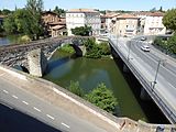
 The Dadou at Briatexte | |
.png) | |
| Location | |
| Country | France |
| Physical characteristics | |
| Source | |
| - location | Saint-Salvi-de-Carcavès |
| - coordinates | 43°47′19″N 02°37′32″E / 43.78861°N 2.62556°E |
| - elevation | 860 m (2,820 ft) |
| Mouth | |
| - location | Agout |
| - coordinates | 43°44′11″N 01°47′24″E / 43.73639°N 1.79000°E |
| - elevation | 110 m (360 ft) |
| Length | 115.8 km (72.0 mi) |
| Basin size | 858 km2 (331 sq mi) |
| Discharge | |
| - average | 12 m3/s (420 cu ft/s) |
Geography
changeThe Dadou river has a length of 115.8 km (72.0 mi) and a drainage basin with an area of 857 km2 (331 sq mi).[1]
Its average yearly discharge (volume of water which passes through a section of the river per unit of time) is 7.81 m3/s (276 cu ft/s) at Montdragon in the Tarn department.[2]

Average monthly discharge (m3/s) at Montdragon (49 years)[2]
Course
changeThe source of the Dadou is on the Monts de Lacaune, in the southern Massif Central, in the commune of Saint-Salvi-de-Carcavès, Tarn department, at an altitude of about 870 m (2,854 ft).[3]
The Agout flows, in general, to the west through the Tarn department and 26 communes.[1] Some of the communes are Montdragon, Graulhet, Briatexte, Lacaze, Rayssac, Saint-Julien-du-Puy, Vénès, Saint-Genest-de-Contest, Le Masnau-Massuguiès, Saint-Salvi-de-Carcavès, Laboutarie, Lombers, Réalmont, Saint-Lieux-Lafenasse, Saint-Antonin-de-Lacalm, Le Travet, Teillet, Arifat, Mont-Roc, Paulinet, Giroussens, Saint-Jean-de-Rives, Ambres, Saint-Gauzens, Puybegon, Montredon-Labessonnié.
Finally, it flows, as a right tributary into the Agout river at Ambres, near Saint-Jean-de-Rives, in the Tarn department, at 115 m (377 ft) of altitude.[4]
Main tributaries
changeThe main tributaries of the Dadou are:
|
Left tributaries:
|
|
Right tributaries:
|
Gallery
change-
 Chateau de Granval ruins and the Dadou river
 -
-


Related pages
changeReferences
change- ↑ 1.0 1.1 "Le Dadou (O47-0400)" (in French). SANDRE - Portail national d'accès aux référentiels sur l'eau. Archived from the original on 6 June 2012. Retrieved 2 February 2017.
- ↑ 2.0 2.1 "Le Dadou à Montdragon" (in French). Banque Hydro. Archived from the original on 3 March 2016. Retrieved 2 February 2017.
- ↑ "Source du Dadou" (in French). Géoportail. Retrieved 2 February 2017.
- ↑ "Confluence du Dadou" (in French). Géoportail. Retrieved 2 February 2017.
Other websites
change- Banque Hydro - Station O4774010 - Le Dadou à Montdragon (Synthèse) Archived 2015-02-19 at the Wayback Machine (in French)
- Syndicat Mixte du Bassin de l'Agout (in French)