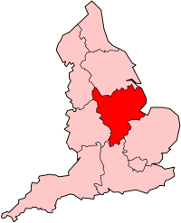
East Midlands
The East Midlands is one of the regions of England and is the eastern half of the Midlands.

The counties of Derbyshire, Leicestershire, Rutland, Northamptonshire, Nottinghamshire and most of Lincolnshire belong to this region.
The highest point in the region is Kinder Scout, in Derbyshire at 2,088 ft (636 m).
Population and settlement change
Its main cities are Nottingham, Leicester, Lincoln, Derby, and Northampton. Leicester is officially the largest city in the region, although the largest area is the Nottingham Urban Area.
East Midlands Airport is situated between the three main cities of Derby, Leicester and Nottingham.
Midland Mainline and GNER trains go to London and to Birmingham and the South West.
The M1 motorway serves the three largest cities.
History change
A historical basis for such an area exists in the Five Burghs of the Danelaw. The current government office region was created in 1994.
Local government change
The official region consists of the following subdivisions:
| Map | Ceremonial county | Shire county /unitary |
Districts |
|---|---|---|---|
| Derbyshire | 1. Derbyshire | High Peak, Derbyshire Dales South Derbyshire, Erewash Amber Valley, North East Derbyshire Chesterfield, Bolsover | |
| 2. Derby | |||
| Nottinghamshire | 3. Nottinghamshire | Rushcliffe, Broxtowe Ashfield, Gedling Newark and Sherwood, Mansfield Bassetlaw | |
| 4. Nottingham | |||
| Lincolnshire |
5. Lincolnshire | Lincoln, North Kesteven South Kesteven, South Holland, Boston, East Lindsey, West Lindsey | |
| Leicestershire | 6. Leicestershire | Charnwood, Melton Harborough, Oadby and Wigston Blaby, Hinckley and Bosworth North West Leicestershire | |
| 7. Leicester | |||
| 8. Rutland | |||
| 9. Northamptonshire | South Northamptonshire, Northampton Daventry, Wellingborough Kettering, Corby East Northamptonshire | ||
Other websites change
- East Midlands Development Agency Archived 2006-03-25 at the Wayback Machine
- East Midland Directory Archived 2008-05-08 at the Wayback Machine
- East Midlands Regional Assembly Archived 2008-03-02 at the Wayback Machine
- Government Office for the East Midlands Archived 2014-05-17 at the Wayback Machine
- Government's list of councils in the East Midlands Archived 2006-09-25 at the Wayback Machine
- East Midland Network Exchange Archived 2007-04-03 at the Wayback Machine