File:Boutonne river map.svg

Size of this PNG preview of this SVG file: 677 × 248 pixels. Other resolutions: 320 × 117 pixels | 640 × 234 pixels | 1,024 × 375 pixels | 1,280 × 469 pixels | 2,560 × 938 pixels.
Original file (SVG file, nominally 677 × 248 pixels, file size: 130 KB)
| This is a file from the Wikimedia Commons. Information from its description page there is shown below. Commons is a freely licensed media file repository. You can help. |
Summary
| Description |
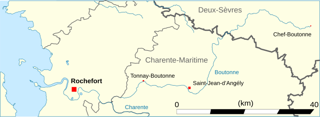
Français : Carte hydrographique de la Boutonne.
English: Map of the Boutonne river. |
| Date | (UTC) |
| Source | |
| Author |
|
| This is a retouched picture, which means that it has been digitally altered from its original version. Modifications: Cadrage (crop). The original can be viewed here: Charente-Maritime-saint-palais.svg:
|
Licensing
I, the copyright holder of this work, hereby publish it under the following licenses:
This file is licensed under the Creative Commons Attribution-Share Alike 3.0 Unported, 2.5 Generic, 2.0 Generic and 1.0 Generic license.
- You are free:
- to share – to copy, distribute and transmit the work
- to remix – to adapt the work
- Under the following conditions:
- attribution – You must give appropriate credit, provide a link to the license, and indicate if changes were made. You may do so in any reasonable manner, but not in any way that suggests the licensor endorses you or your use.
- share alike – If you remix, transform, or build upon the material, you must distribute your contributions under the same or compatible license as the original.

|
Permission is granted to copy, distribute and/or modify this document under the terms of the GNU Free Documentation License, Version 1.2 or any later version published by the Free Software Foundation; with no Invariant Sections, no Front-Cover Texts, and no Back-Cover Texts. A copy of the license is included in the section entitled GNU Free Documentation License. |
You may select the license of your choice.
Original upload log
This image is a derivative work of the following images:
- File:Charente-Maritime-saint-palais.svg licensed with Cc-by-sa-3.0,2.5,2.0,1.0, GFDL
- 2009-03-16T11:48:08Z Droop 942x1132 (1216432 Bytes) {{Information |Description={{fr|1=Localisation de la commune de Saint-Palais-sur-Mer en Charente-Maritime.}} |Source=travail personnel (own work) |Author=[[User:Droop|Droop]] |Date=16 mars 2008 |Permission= |other_versions= F
File history
Click on a date/time to view the file as it appeared at that time.
| Date/Time | Thumbnail | Dimensions | User | Comment | |
|---|---|---|---|---|---|
| current | 17:47, 7 April 2009 | 677 × 248 (130 KB) | VIGNERON | ||
| 17:30, 7 April 2009 | 677 × 248 (130 KB) | VIGNERON | {{Information |Description={{en|1=Carte hydrographique de la Boutonne}} |Source=travail personnel (own work) |Author=VIGNERON |Date= |Permission= |other_versions= }} <!--{{ImageUpload|full}}--> |
File usage
The following page uses this file:
Global file usage
The following other wikis use this file: