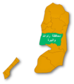
File:Governate of Ramallah and el-Beireh.png

Size of this preview: 522 × 599 pixels. Other resolutions: 209 × 240 pixels | 418 × 480 pixels | 669 × 768 pixels | 1,066 × 1,223 pixels.
Original file (1,066 × 1,223 pixels, file size: 204 KB, MIME type: image/png)
File history
Click on a date/time to view the file as it appeared at that time.
| Date/Time | Thumbnail | Dimensions | User | Comment | |
|---|---|---|---|---|---|
| current | 14:02, 2 December 2007 |  | 1,066 × 1,223 (204 KB) | Producer | {{Information |Description= Map of the Palestinian Authorities showing the Governate of Ramallah and el_Beireh |Source=self-made |Date=30 November 2007 |Author= -- ~~~~ |Permission=Look Bellow |other_versions= }} Category:Palestinian territories[[Cate |
File usage
The following 3 pages use this file:
Global file usage
The following other wikis use this file:
- Usage on ar.wikipedia.org
- رام الله
- بيرزيت
- عارورة
- قبيا
- سنجل
- البيرة (رام الله)
- جفنا (فلسطين)
- دورا القرع
- عين سينيا
- بدرس
- ترمسعيا
- عين يبرود
- عابود
- المزرعة الشرقية
- جلجيليا
- دير قديس
- رمون
- دير غسانة
- بيتونيا
- بيت عور التحتا
- سردا
- مزارع النوباني
- عطارة (رام الله)
- محافظات السلطة الوطنية الفلسطينية
- بيت ريما
- خربة أبو فلاح
- قالب:محافظة رام الله والبيرة
- دير جرير
- كفر مالك
- رنتيس
- أبو قش (قرية)
- دير أبو مشعل
- كوبر
- سلواد
- كفر عين
- دير نظام
- بيت لقيا
- خربثا المصباح
- دير عمار
- صفا
- نعلين
- كفر نعمة
- عبوين
- الطيبة (رام الله)
- بيتين
- دير السودان
- قراوة بني زيد
- بيتللو
- عين عريك
- بيت سيرا
View more global usage of this file.