Gartempe
The Gartempe is a French river that flows through the Nouvelle-Aquitaine and Centre-Val de Loire regions.
| Gartempe | |
|---|---|
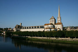
 The Gartempe bridge in Saint-Savin | |
 | |
| Location | |
| Country | France |
| Regions | Centre-Val de Loire and Nouvelle-Aquitaine |
| Physical characteristics | |
| Source | |
| - location | Limousin |
| Mouth | |
| - location | Creuse |
| - coordinates | 46°47′3″N 0°49′48″E / 46.78417°N 0.83000°E |
| Length | 205 km (127 mi) |
| Basin size | 3,950 km2 (1,530 sq mi) |
It rises in the Massif Central and flows into the Creuse river, as a left tributary, in the Vienne department.
Geography
changeThe Gartempe river has a length of 204.6 km (127 mi) and a drainage basin with an area of approximately 3,913 km2 (1,511 sq mi).[1]
Course
changeThe Gartempe river starts in western Massif Central, near the hamlet of Pétillat in the commune of Peyrabout, Creuse department, at an elevation of about 640 m (2,100 ft).[2] From here, it generally flows to the northwest.
Finally, the river flows into the Creuse river in La Roche-Posay (Vienne department, on the left side) and Yzeures-sur-Creuse (Indre-et-Loire department, on the right side).[3]
The Gartempe flows through 5 departments and 46 communes, in 2 regions:[1]
Main tributaries
changeThe main tributaries of the Gartempe river are:[1]
|
Left tributaries:
|
Right tributaries:
|
Gallery
change-
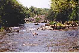 The Gartempe in Portes d'Enfer
 -
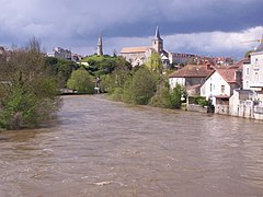 The Gartempe in Montmorillon
 -
-
 Confluence with the Creuse river


.jpg)

Related pages
changeReferences
change- ↑ 1.0 1.1 1.2 "La Gartempe (L5--0180)" (in French). SANDRE - Portail national d'accès aux référentiels sur l'eau. Archived from the original on 3 March 2016. Retrieved 30 July 2016.
- ↑ "Source de la Gartempe" (in French). Géoportail. Retrieved 30 July 2016.
- ↑ "Confluence de la Gartempe" (in French). Géoportail. Retrieved 30 July 2016.
Other websites
change- Banque Hydro - Station L5411810 - La Gartempe à Montmorillon Archived 2015-02-19 at the Wayback Machine (in French)
- Bassin versant de la Gartempe Archived 2014-10-19 at the Wayback Machine (in French)
- Syndicat intercommunal d'aménagement de la Gartempe (SIAG) (in French)