Indian subcontinent
The Indian subcontinent is a term mainly used for the geographic region which includes: Bangladesh, Bhutan, Republic of India, Maldives, Nepal, Pakistan, and Sri Lanka. It is north of the Indian Ocean. It is south of the Himalayas, one of the world's largest ranges of tall mountains.[1]


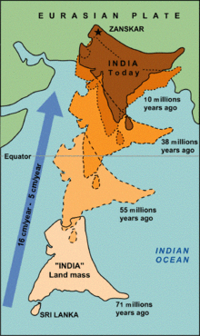
The subcontinent was once part of Gondwana, the ancient southern supercontinent. Geologically, the origin of the Himalayas is the impact of the Indian tectonic plate travelling northward at 15 cm per year to slowly squeeze the Eurasian continent, about 40-50 million years ago.[2][3] The formation of the Himalayan arc resulted in the rock of the seabeds of that time being uplifted into mountains. An often-cited fact used to illustrate this process is that the summit of Mount Everest is made of marine limestone.[4]
About 50 million years ago, this fast moving plate had completely closed the Tethys Ocean. The existence of the Tethys has been proved by sedimentary rocks settled on the ocean floor, and the volcanoes that fringed its edges. Since these sediments were light, they crumpled into mountain ranges rather than sank to the floor. The Indian plate is still driving horizontally below the Tibetan Plateau, which forces the plateau to move upwards.[2]
The Indo-Australian plate is still moving at 67 mm per year.[5] Over the next 10 million years it may travel about 1,500 km into Asia. About 20 mm per year of the India-Asia convergence is absorbed by thrusting along the Himalaya southern front. This leads to the Himalayas rising by about 5 mm per year, making them geologically active. The movement of the Indian plate into the Asian plate also leads to earthquakes from time to time.
Related pages
changeReference
change- ↑ "Indian subcontinent | Map, Countries, Population, & History | Britannica". www.britannica.com. 2023-11-22. Retrieved 2023-12-05.
- ↑ 2.0 2.1 Kind, Rainer 2007. "The fastest continent: India's truncated lithospheric roots". Helmholtz Association of German Research Centres. Archived from the original on 2019-06-18. Retrieved 2013-08-08.
{{cite web}}: CS1 maint: numeric names: authors list (link) - ↑ Levin, Harold 2006. The Earth through time. 8th ed, Wiley, p189 and following. ISBN 0-471-69743-5
- ↑ "A site which uses this dramatic fact first used in illustration of "deep time" in John McPhee's book Basin and Range". Archived from the original on 2016-03-03. Retrieved 2011-08-26.
- ↑ Kumar, Prakash et al. 2007 (2007). "The rapid drift of the Indian tectonic plate" (PDF). Nature. 449 (7164): 894–897. Bibcode:2007Natur.449..894K. doi:10.1038/nature06214. PMID 17943128. S2CID 4339656.
{{cite journal}}: CS1 maint: numeric names: authors list (link)