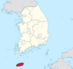
Jeju Island
Jejudo (also known as Jeju Island) is the largest island off the coast of the Korean Peninsula. It is the main island of Jeju Province of South Korea. The island lies in the Korea Strait, southwest of South Jeolla Province. The island contains the natural World Heritage Site Jeju Volcanic Island and Lava Tubes.[2] The highest point in South Korea is the Island's dormant volcano, Hallasan, which stands 6,400 feet (2,000 m) above sea level.[3] Jejudo has a temperate climate. Even in winter, the temperature rarely falls below 0 °C (32 °F). The Island is a popular place for Korean newlyweds to honeymoon.[4]
Jeju Province
제주도 | |
|---|---|
| Korean transcription(s) | |
| • Hangul | 제주특별자치도 |
| • Hanja | 濟州特別自治道 |
| • McCune‑Reischauer | Cheju T'ŭkpyŏl Chach'ido |
| • Revised Romanization | Jeju Teukbyeoljachi-do |
 | |
 | |
| Country | South Korea |
| Region | Jeju |
| Capital | Jeju City |
| Subdivisions | 2 cities; 0 counties |
| Government | |
| • Governor | Won Hee-ryong (Independent) |
| • Body | Jeju Provincial Council |
| • National Representation - National Assembly | 3 / 253 1.19% (constituency seats) |
| Area | |
| • Total | 1,849 km2 (714 sq mi) |
| • Rank | 9th |
| Population (October, 2014) | |
| • Total | 604,771 |
| • Rank | 9th |
| • Density | 327.1/km2 (847/sq mi) |
| Metropolitan Symbols | |
| • Flower | Rhododendron |
| • Tree | Cinnamomum camphora |
| • Bird | Woodpecker |
| Area code | +82-64-7xx |
| Dialect | Jeju |
| HDI (2017) | 0.888[1] very high |
| Website | Official Website |
| Jeju Island | |
| Hangul | 제주도 |
|---|---|
| Hanja | 濟州島 |
| Revised Romanization | Jejudo |
| McCune–Reischauer | Chejudo |
- This article is about the island itself. For the province, see Jeju-do. For the World Heritage Site, see Jeju Volcanic Island and Lava Tubes.
Jeju Island is 73 km wide from east to west and 31 km wide from north to south.[5] Most of Jeju Island is made out of volcanic rocks from the Holocene era.[6]
First, the basalt lava erupted to make the Hallasan shield volcano about 2 million years ago. Hallasan was still active into recorded history, but it is not active now. Then this first layer of volcanic rock was covered up with sediment. Then there was another set of eruptions, which made most of the rock on the surface of Jeju Island today. In the third round of volcanic activity, Hallasan grew to its current, tall height, 1950 m.[6]
References
change- ↑ "Sub-national HDI - Area Database - Global Data Lab". hdi.globaldatalab.org. Retrieved 2018-09-13.
- ↑ "Unesco names World Heritage sites". BBC News. June 28, 2007. Retrieved May 6, 2010.
- ↑ "10 reasons travelers can't keep away from Jeju Island". CNN Travel. CNN/Turner Broadcasting System, Inc. Retrieved 3 September 2016.
- ↑ "Jeju (Cheju) Island Travel Information". Life in Asia, Inc. Retrieved 3 September 2016.
- ↑ Kyung Sik Woo; Young Kwan Sohn; Ung San Ahn; Seok Hoon Yoon; Andy Spate (July 3, 2013). Geology of Jeju Island. Springer. pp. 13–14. doi:10.1007/978-3-642-20564-4_5. ISBN 978-3-642-20564-4. Retrieved August 18, 2020.
- ↑ 6.0 6.1 Yoshiyuki Tatsumi; Hiroshi Shukuno; Masako Yoshikawa; Qing Chang; Keiko Sato; Moon Won Lee (March 2005). "The Petrology and Geochemistry of Volcanic Rocks on Jeju Island: Plume Magmatism along the Asian Continental Margin". Journal of Petrology. 46 (3): 523–553. doi:10.1093/petrology/egh087. Retrieved August 18, 2020.
