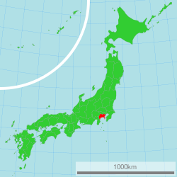
Kanagawa Prefecture
This article may have too many red links. (November 2020) |
Kanagawa Prefecture (神奈川県, Kanagawa-ken) is a prefecture in the Kantō region of Japan on the island of Honshu.[1] The capital city is Yokohama.[2]
Kanagawa Prefecture
神奈川県 | |
|---|---|
| Japanese transcription(s) | |
| • Romaji | Kanagawa-ken |
 Location of Kanagawa in Japan | |
| Coordinates: 35°26′51.9″N 139°38′33.1″E / 35.447750°N 139.642528°E | |
| Country | |
| Region | Kantō |
| Island | Honshū |
| Capital | Yokohama |
| ISO 3166 code | JP-14 |
| Website | www |
History
changeKanagawa was created from the lands of Sagami Province and Musashi Province.[3]
In 1853, Commodore Matthew Perry landed at Kanagawa.
In 1854, the Japanese-American Convention of Kanagawa opened Japanese ports to the United States.
In 1923, the center of the Great Kantō earthquake was deep beneath Izu Ōshima Island in Sagami Bay.[4]
Geography
changeKanagawa is in the southeastern corner of the Kantō Plain. The prefecture is between Tokyo on the north, the foothills of Mount Fuji on the northwest, and the Sagami Bay and Tokyo Bay on the south and east. The western border is shared with Yamanashi Prefecture and Shizuoka Prefecture.
Cities
changeThere are nineteen cities in Kanagawa Prefecture:
|
Towns and villages
changeNational Parks
changeNational Parks are established in about 23% of the total land area of the prefecture.[5]
Shrines and Temples
changeSamukawa jinja and Hikawa jinja are the chief Shinto shrines (ichinomiya) in the prefecture.[6]
Related pages
changeReferences
change- ↑ Nussbaum, Louis-Frédéric. (2005). "Kanagawa" in Japan Encyclopedia, p. 466; "Kantō" at p. 479.
- ↑ Nussbaum, "Yokohama" at pp. 1054-1055.
- ↑ Nussbaum, "Provinces and prefectures" at p. 780.
- ↑ Hammer, Joshua. (2006). Yokohama Burning: the Deadly 1923 Earthquake and Fire that Helped Forge the Path to World War II, p. 278.
- ↑ Japan Ministry of the Environment, "General overview of area figures for Natural Parks by prefecture". Retrieved 2012-3-13.
- ↑ "Nationwide List of Ichinomiya," p. 2 Archived 2013-05-17 at the Wayback Machine. Retrieved 2012-3-14.
Other websites
changeMedia related to Kanagawa prefecture at Wikimedia Commons

